Jayapura geodata
Jayapura (Papua) is a seat of a first-order administrative division; located in Indonesia in Asia/Jayapura (GMT+9) time zone. With population of 134,895 people, there are 87 cities with bigger population in this country. Compared to other cities in Indonesia, 92.1% of cities are located further ↓South; 99.9% of cities are located further ←West and 89% of cities have higher elevation than Jayapura. Note1


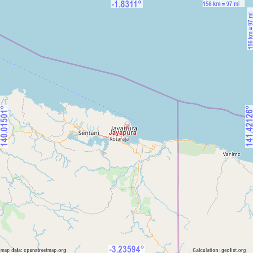
Jayapura GPS coordinates[2]
2° 32' 1.356" South, 140° 43' 5.268" East
| Map corner | latitude | longitude |
|---|---|---|
| Upper-left | -1.8311°, | 140.01501° |
| Center: | -2.53371°, | 140.71813° |
| Lower-right: | -3.23594°, | 141.42126° |
| Map W x H: | 156.2×156.2 km | = 97.1×97.1mi |
| max Lat: | 5.88969° ⇑7.9% North |
| Jayapura: | -2.53371° |
| min Lat: | ⇓92.1% South -10.934° |
| min Long | Jayapura | max Long |
| 95.1345° | 140.71813° | 140.9419° |
| W 99.9%⇐ | ⇒0.099999999999994% E |
Elevation
Elevation of Jayapura is 11 m = 36 ft, and this is 218.7 m = 718 ft below average elevation for this country.
| Max E: |
3185 m = 10449 ft | 89% |
| Avg. | 229.7 m = 754 ft | |
| Jayapura | 11 m = 36 ft | |
Min E: |
-1 m = -3 ft | 11% |
See also: Jayapura elevation on elevation.city.
Geographical zone
Jayapura is located in South Torrid zone (between Equator and Tropic of Capricorn). Distance of Equator is 281.7 km =175 mi to North.| Distance of | km | miles | from Jayapura |
|---|---|---|---|
| Equator | 281.7 | 175 | to North |
| Tropic Capricorn | 2324.2 | 1444.2 | to South |
| Antarctic Circle | 7119.5 | 4423.9 | to South |
| South Pole | 9725.3 | 6043 | to South |


Nearby cities:
15 places around Jayapura: (largest is in red/bold)
• Abepura
11.8 km =7.3 mi,  233°
233°
• Armopa
122.4 km =76.1 mi,  280°
280°
• Arso
41.4 km =25.7 mi,  172°
172°
• Banda
76 km =47.2 mi,  160°
160°
• Betaf
169.3 km =105.2 mi,  285°
285°
• Demta
66.3 km =41.2 mi, 287°
• Depapre
38.9 km =24.2 mi, 277°
• Elelim
176.5 km =109.7 mi,  219°
219°
• Genyem
63.4 km =39.4 mi,  265°
265°
• Guay
100.9 km =62.7 mi, 271°
• Sawoi
43.7 km =27.2 mi,  256°
256°
• Sengge
101.8 km =63.3 mi,  176°
176°
• Sentani
23.2 km =14.4 mi, 260°
• Ubrub
132.4 km =82.3 mi, 172°
• Waris
67.4 km =41.9 mi, 164°
Sources, notices
• [Note1] Compared only with cities in Indonesia existing in our database
• [Src1] Map data: © OpenStreetMap contributors (CC-BY-SA)
• [Src2] Other city data from geonames.org with taken over terms of usage.
• [Src3] Geographical zone / Annual Mean Temperature by Robert A. Rohde @ Wikipedia
