Yairipok geodata
Yairipok (Manipur) is a populated place; located in India in Asia/Kolkata (GMT+5.5) time zone. With population of 8,797 people, there are 3060 cities with bigger population in this country. Compared to other cities in India, 61.7% of cities are located further ↓South; 98.7% of cities are located further ←West and 93.9% of cities have lower elevation than Yairipok. Note1


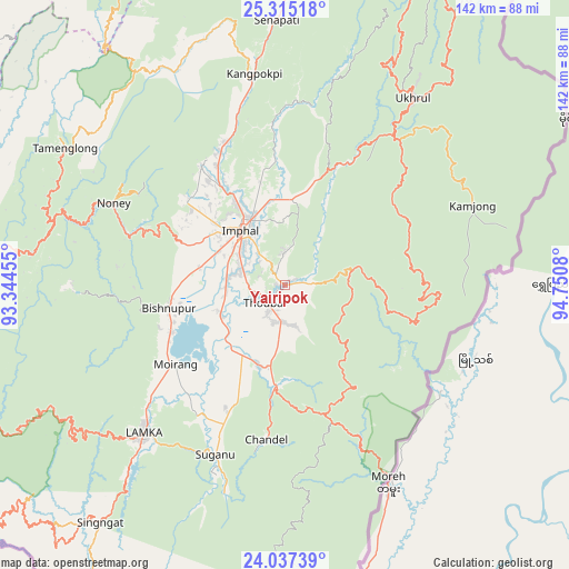
Yairipok GPS coordinates[2]
24° 40' 40.512" North, 94° 2' 51.612" East
| Map corner | latitude | longitude |
|---|---|---|
| Upper-left | 25.31518°, | 93.34455° |
| Center: | 24.67792°, | 94.04767° |
| Lower-right: | 24.03739°, | 94.7508° |
| Map W x H: | 142.1×142.1 km | = 88.3×88.3mi |
| max Lat: | 34.9274° ⇑38.3% North |
| Yairipok: | 24.67792° |
| min Lat: | ⇓61.7% South 8.09008° |
| min Long | Yairipok | max Long |
| 68.82655° | 94.04767° | 96.81° |
| W 98.7%⇐ | ⇒1.3% E |
Elevation
Elevation of Yairipok is 791 m = 2595 ft, and this is 495.4 m = 1625 ft above average elevation for this country.
| Max E: |
3681 m = 12077 ft | 6.1% |
| Yairipok | 791 m 2595 ft | |
| Avg. | 295.6 m = 970 ft | |
Min E: |
1 m = 3 ft | 93.9% |
See also: India elevation on elevation.city.
Geographical zone
Yairipok is located in North temperate zone (between Tropic of Cancer and the Arctic Circle). Distance of this Northern Tropic circle is 138 km =85.7 mi to South.| Distance of | km | miles | from Yairipok |
|---|---|---|---|
| North Pole | 7263.1 | 4513.1 | to North |
| Arctic Circle | 4657.2 | 2893.8 | to North |
| Tropic Cancer | 138 | 85.7 | to South |
| Equator | 2743.9 | 1705 | to South |


Nearby cities:
15 places around Yairipok: (largest is in red/bold)
• Bishnupur
29.4 km =18.3 mi,  259°
259°
• Chandel
39 km =24.2 mi,  186°
186°
• Churāchāndpur
54.1 km =33.6 mi,  224°
224°
• Imphal
17.8 km =11.1 mi,  324°
324°
• Jiribam
94.6 km =58.8 mi,  278°
278°
• Kakching
21.1 km =13.1 mi,  198°
198°
• Kamjong
51.3 km =31.9 mi,  66°
66°
• Kāngpokpi
53.3 km =33.1 mi,  351°
351°
• Lakhipur
105.7 km =65.7 mi, 276°
• Mayāng Imphāl
17.8 km =11.1 mi,  244°
244°
• Moirāng
33.9 km =21.1 mi,  233°
233°
• Pherzawl
98.4 km =61.1 mi, 242°
• Tengnoupal
34 km =21.1 mi,  162°
162°
• Thoubāl
6.8 km =4.2 mi, 229°
• Wāngjing
10 km =6.2 mi,  170°
170°
Sources, notices
• [Note1] Compared only with cities in India existing in our database
• [Src1] Map data: © OpenStreetMap contributors (CC-BY-SA)
• [Src2] Other city data from geonames.org with taken over terms of usage.
• [Src3] Geographical zone / Annual Mean Temperature by Robert A. Rohde @ Wikipedia
