Pherzawl geodata
Pherzawl (Manipur) is a seat of a second-order administrative division; located in India in Asia/Kolkata (GMT+5.5) time zone. In our database, there are 3475 cities with bigger population. Compared to other cities in India, 59.3% of cities are located further ↓South; 98.1% of cities are located further ←West and 96.2% of cities have lower elevation than Pherzawl. Note1


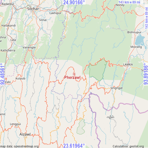
Pherzawl GPS coordinates[2]
24° 15' 44.172" North, 93° 11' 19.428" East
| Map corner | latitude | longitude |
|---|---|---|
| Upper-left | 24.90166°, | 92.48561° |
| Center: | 24.26227°, | 93.18873° |
| Lower-right: | 23.61964°, | 93.89186° |
| Map W x H: | 142.5×142.5 km | = 88.5×88.5mi |
| max Lat: | 34.9274° ⇑40.7% North |
| Pherzawl: | 24.26227° |
| min Lat: | ⇓59.3% South 8.09008° |
| min Long | Pherzawl | max Long |
| 68.82655° | 93.18873° | 96.81° |
| W 98.1%⇐ | ⇒1.9% E |
Elevation
Elevation of Pherzawl is 1017 m = 3337 ft, and this is 721.4 m = 2367 ft above average elevation for this country.
| Max E: |
3681 m = 12077 ft | 3.8% |
| Pherzawl | 1017 m 3337 ft | |
| Avg. | 295.6 m = 970 ft | |
Min E: |
1 m = 3 ft | 96.2% |
See also: India elevation on elevation.city.
Geographical zone
Pherzawl is located in North temperate zone (between Tropic of Cancer and the Arctic Circle). Distance of this Northern Tropic circle is 91.8 km =57 mi to South.| Distance of | km | miles | from Pherzawl |
|---|---|---|---|
| North Pole | 7309.4 | 4541.8 | to North |
| Arctic Circle | 4703.5 | 2922.6 | to North |
| Tropic Cancer | 91.8 | 57 | to South |
| Equator | 2697.7 | 1676.3 | to South |


Nearby cities:
15 places around Pherzawl: (largest is in red/bold)
• Aizawl
76.2 km =47.3 mi,  218°
218°
• Bishnupur
70.9 km =44.1 mi,  54°
54°
• Churāchāndpur
49.4 km =30.7 mi,  80°
80°
• Darlawn
38.5 km =23.9 mi, 224°
• Hailākāndi
79 km =49.1 mi,  306°
306°
• Jiribam
60.6 km =37.7 mi,  353°
353°
• Kolasib
51.9 km =32.2 mi,  265°
265°
• Lakhipur
61.7 km =38.3 mi,  342°
342°
• Lāla
66.5 km =41.3 mi,  299°
299°
• Mamit
80.1 km =49.8 mi,  242°
242°
• Mayāng Imphāl
80.7 km =50.1 mi,  61°
61°
• Moirāng
65.1 km =40.5 mi,  66°
66°
• Sairang
74.1 km =46 mi,  227°
227°
• Silchar
74.2 km =46.1 mi,  327°
327°
• Sāitlaw
70.2 km =43.6 mi, 242°
Sources, notices
• [Note1] Compared only with cities in India existing in our database
• [Src1] Map data: © OpenStreetMap contributors (CC-BY-SA)
• [Src2] Other city data from geonames.org with taken over terms of usage.
• [Src3] Geographical zone / Annual Mean Temperature by Robert A. Rohde @ Wikipedia
