Thoubāl geodata
Thoubāl (Manipur) is a populated place; located in India in Asia/Kolkata (GMT+5.5) time zone. With population of 44,493 people, there are 992 cities with bigger population in this country. Compared to other cities in India, 61.4% of cities are located further ↓South; 98.7% of cities are located further ←West and 93.7% of cities have lower elevation than Thoubāl. Note1


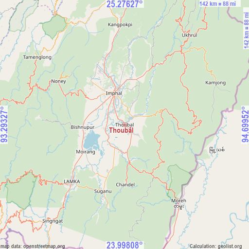
Thoubāl GPS coordinates[2]
24° 38' 19.716" North, 93° 59' 47.004" East
| Map corner | latitude | longitude |
|---|---|---|
| Upper-left | 25.27627°, | 93.29327° |
| Center: | 24.63881°, | 93.99639° |
| Lower-right: | 23.99808°, | 94.69952° |
| Map W x H: | 142.1×142.1 km | = 88.3×88.3mi |
| max Lat: | 34.9274° ⇑38.6% North |
| Thoubāl: | 24.63881° |
| min Lat: | ⇓61.4% South 8.09008° |
| min Long | Thoubāl | max Long |
| 68.82655° | 93.99639° | 96.81° |
| W 98.7%⇐ | ⇒1.3% E |
Elevation
Elevation of Thoubāl is 780 m = 2559 ft, and this is 484.4 m = 1589 ft above average elevation for this country.
| Max E: |
3681 m = 12077 ft | 6.3% |
| Thoubāl | 780 m 2559 ft | |
| Avg. | 295.6 m = 970 ft | |
Min E: |
1 m = 3 ft | 93.7% |
See also: Thoubāl elevation on elevation.city.
Geographical zone
Thoubāl is located in North temperate zone (between Tropic of Cancer and the Arctic Circle). Distance of this Northern Tropic circle is 133.7 km =83.1 mi to South.| Distance of | km | miles | from Thoubāl |
|---|---|---|---|
| North Pole | 7267.5 | 4515.8 | to North |
| Arctic Circle | 4661.6 | 2896.6 | to North |
| Tropic Cancer | 133.7 | 83.1 | to South |
| Equator | 2739.6 | 1702.3 | to South |


Nearby cities:
15 places around Thoubāl: (largest is in red/bold)
• Bishnupur
23.7 km =14.7 mi,  267°
267°
• Chandel
34.4 km =21.4 mi,  178°
178°
• Churāchāndpur
47.4 km =29.5 mi,  224°
224°
• Imphal
19.5 km =12.1 mi,  344°
344°
• Jiribam
90.3 km =56.1 mi,  281°
281°
• Kakching
15.7 km =9.8 mi,  185°
185°
• Kamjong
57.8 km =35.9 mi,  65°
65°
• Kāngpokpi
57.2 km =35.5 mi,  357°
357°
• Lakhipur
101.2 km =62.9 mi, 279°
• Mayāng Imphāl
11.3 km =7 mi,  253°
253°
• Moirāng
27.1 km =16.8 mi,  234°
234°
• Pherzawl
91.8 km =57 mi,  242°
242°
• Tengnoupal
32 km =19.9 mi,  151°
151°
• Wāngjing
8.8 km =5.5 mi,  128°
128°
• Yairipok
6.8 km =4.2 mi,  49°
49°
Sources, notices
• [Note1] Compared only with cities in India existing in our database
• [Src1] Map data: © OpenStreetMap contributors (CC-BY-SA)
• [Src2] Other city data from geonames.org with taken over terms of usage.
• [Src3] Geographical zone / Annual Mean Temperature by Robert A. Rohde @ Wikipedia
