Moirāng geodata
Moirāng (Manipur) is a populated place; located in India in Asia/Kolkata (GMT+5.5) time zone. With population of 17,103 people, there are 2274 cities with bigger population in this country. Compared to other cities in India, 60.6% of cities are located further ↓South; 98.4% of cities are located further ←West and 93.4% of cities have lower elevation than Moirāng. Note1


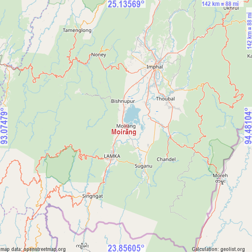
Moirāng GPS coordinates[2]
24° 29' 51" North, 93° 46' 40.476" East
| Map corner | latitude | longitude |
|---|---|---|
| Upper-left | 25.13569°, | 93.07479° |
| Center: | 24.4975°, | 93.77791° |
| Lower-right: | 23.85605°, | 94.48104° |
| Map W x H: | 142.3×142.3 km | = 88.4×88.4mi |
| max Lat: | 34.9274° ⇑39.4% North |
| Moirāng: | 24.4975° |
| min Lat: | ⇓60.6% South 8.09008° |
| min Long | Moirāng | max Long |
| 68.82655° | 93.77791° | 96.81° |
| W 98.4%⇐ | ⇒1.6% E |
Elevation
Elevation of Moirāng is 773 m = 2536 ft, and this is 477.4 m = 1566 ft above average elevation for this country.
| Max E: |
3681 m = 12077 ft | 6.6% |
| Moirāng | 773 m 2536 ft | |
| Avg. | 295.6 m = 970 ft | |
Min E: |
1 m = 3 ft | 93.4% |
See also: India elevation on elevation.city.
Geographical zone
Moirāng is located in North temperate zone (between Tropic of Cancer and the Arctic Circle). Distance of this Northern Tropic circle is 117.9 km =73.3 mi to South.| Distance of | km | miles | from Moirāng |
|---|---|---|---|
| North Pole | 7283.2 | 4525.6 | to North |
| Arctic Circle | 4677.3 | 2906.3 | to North |
| Tropic Cancer | 117.9 | 73.3 | to South |
| Equator | 2723.9 | 1692.6 | to South |


Nearby cities:
15 places around Moirāng: (largest is in red/bold)
• Bishnupur
14.7 km =9.1 mi,  353°
353°
• Chandel
29.5 km =18.3 mi,  129°
129°
• Churāchāndpur
21.3 km =13.2 mi,  210°
210°
• Imphal
38.4 km =23.9 mi,  25°
25°
• Jiribam
74.6 km =46.4 mi,  297°
297°
• Kakching
20.6 km =12.8 mi,  89°
89°
• Kamjong
84.6 km =52.6 mi,  61°
61°
• Kāngpokpi
75.4 km =46.9 mi,  15°
15°
• Lakhipur
84.3 km =52.4 mi,  292°
292°
• Mayāng Imphāl
16.8 km =10.4 mi,  41°
41°
• Pherzawl
65.1 km =40.5 mi,  246°
246°
• Tengnoupal
39.4 km =24.5 mi,  108°
108°
• Thoubāl
27.1 km =16.8 mi,  54°
54°
• Wāngjing
30.7 km =19.1 mi,  70°
70°
• Yairipok
33.9 km =21.1 mi, 53°
Sources, notices
• [Note1] Compared only with cities in India existing in our database
• [Src1] Map data: © OpenStreetMap contributors (CC-BY-SA)
• [Src2] Other city data from geonames.org with taken over terms of usage.
• [Src3] Geographical zone / Annual Mean Temperature by Robert A. Rohde @ Wikipedia
