Churāchāndpur geodata
Churāchāndpur (Manipur) is a populated place; located in India in Asia/Kolkata (GMT+5.5) time zone. With population of 47,774 people, there are 922 cities with bigger population in this country. Compared to other cities in India, 59.7% of cities are located further ↓South; 98.2% of cities are located further ←West and 95.7% of cities have lower elevation than Churāchāndpur. Note1


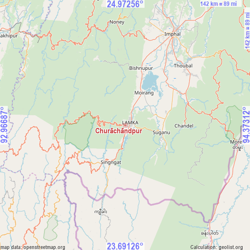
Churāchāndpur GPS coordinates[2]
24° 20' 0.708" North, 93° 40' 11.964" East
| Map corner | latitude | longitude |
|---|---|---|
| Upper-left | 24.97256°, | 92.96687° |
| Center: | 24.33353°, | 93.66999° |
| Lower-right: | 23.69126°, | 94.37312° |
| Map W x H: | 142.5×142.5 km | = 88.5×88.5mi |
| max Lat: | 34.9274° ⇑40.3% North |
| Churāchāndpur: | 24.33353° |
| min Lat: | ⇓59.7% South 8.09008° |
| min Long | Churāchāndpur | max Long |
| 68.82655° | 93.66999° | 96.81° |
| W 98.2%⇐ | ⇒1.8% E |
Elevation
Elevation of Churāchāndpur is 944 m = 3097 ft, and this is 648.4 m = 2127 ft above average elevation for this country.
| Max E: |
3681 m = 12077 ft | 4.3% |
| Churāchāndpur | 944 m 3097 ft | |
| Avg. | 295.6 m = 970 ft | |
Min E: |
1 m = 3 ft | 95.7% |
See also: Churāchāndpur elevation on elevation.city.
Geographical zone
Churāchāndpur is located in North temperate zone (between Tropic of Cancer and the Arctic Circle). Distance of this Northern Tropic circle is 99.7 km =62 mi to South.| Distance of | km | miles | from Churāchāndpur |
|---|---|---|---|
| North Pole | 7301.4 | 4536.9 | to North |
| Arctic Circle | 4695.5 | 2917.6 | to North |
| Tropic Cancer | 99.7 | 62 | to South |
| Equator | 2705.6 | 1681.2 | to South |


Nearby cities:
15 places around Churāchāndpur: (largest is in red/bold)
• Bishnupur
34.1 km =21.2 mi,  15°
15°
• Chandel
33.8 km =21 mi,  90°
90°
• Darlawn
83.6 km =51.9 mi,  244°
244°
• Imphal
59.6 km =37 mi,  27°
27°
• Jiribam
76.3 km =47.4 mi,  313°
313°
• Kakching
36.4 km =22.6 mi,  59°
59°
• Kāngpokpi
96 km =59.7 mi, 18°
• Lakhipur
84.1 km =52.3 mi, 307°
• Mayāng Imphāl
37.9 km =23.5 mi,  35°
35°
• Moirāng
21.3 km =13.2 mi, 30°
• Pherzawl
49.4 km =30.7 mi,  260°
260°
• Tengnoupal
48.7 km =30.3 mi,  83°
83°
• Thoubāl
47.4 km =29.5 mi, 44°
• Wāngjing
49 km =30.4 mi,  54°
54°
• Yairipok
54.1 km =33.6 mi, 44°
Sources, notices
• [Note1] Compared only with cities in India existing in our database
• [Src1] Map data: © OpenStreetMap contributors (CC-BY-SA)
• [Src2] Other city data from geonames.org with taken over terms of usage.
• [Src3] Geographical zone / Annual Mean Temperature by Robert A. Rohde @ Wikipedia
