Kakching geodata
Kakching (Manipur) is a seat of a second-order administrative division; located in India in Asia/Kolkata (GMT+5.5) time zone. With population of 30,418 people, there are 1424 cities with bigger population in this country. Compared to other cities in India, 60.6% of cities are located further ↓South; 98.7% of cities are located further ←West and 93.8% of cities have lower elevation than Kakching. Note1


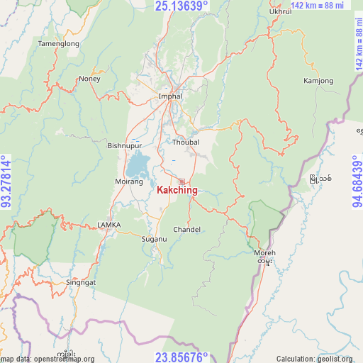
Kakching GPS coordinates[2]
24° 29' 53.52" North, 93° 58' 52.536" East
| Map corner | latitude | longitude |
|---|---|---|
| Upper-left | 25.13639°, | 93.27814° |
| Center: | 24.4982°, | 93.98126° |
| Lower-right: | 23.85676°, | 94.68439° |
| Map W x H: | 142.3×142.3 km | = 88.4×88.4mi |
| max Lat: | 34.9274° ⇑39.4% North |
| Kakching: | 24.4982° |
| min Lat: | ⇓60.6% South 8.09008° |
| min Long | Kakching | max Long |
| 68.82655° | 93.98126° | 96.81° |
| W 98.7%⇐ | ⇒1.3% E |
Elevation
Elevation of Kakching is 787 m = 2582 ft, and this is 491.4 m = 1612 ft above average elevation for this country.
| Max E: |
3681 m = 12077 ft | 6.2% |
| Kakching | 787 m 2582 ft | |
| Avg. | 295.6 m = 970 ft | |
Min E: |
1 m = 3 ft | 93.8% |
See also: India elevation on elevation.city.
Geographical zone
Kakching is located in North temperate zone (between Tropic of Cancer and the Arctic Circle). Distance of this Northern Tropic circle is 118 km =73.3 mi to South.| Distance of | km | miles | from Kakching |
|---|---|---|---|
| North Pole | 7283.1 | 4525.5 | to North |
| Arctic Circle | 4677.2 | 2906.3 | to North |
| Tropic Cancer | 118 | 73.3 | to South |
| Equator | 2723.9 | 1692.6 | to South |


Nearby cities:
15 places around Kakching: (largest is in red/bold)
• Bishnupur
26.5 km =16.5 mi,  303°
303°
• Chandel
18.9 km =11.7 mi,  173°
173°
• Churāchāndpur
36.4 km =22.6 mi,  239°
239°
• Imphal
34.7 km =21.6 mi,  353°
353°
• Jiribam
93.3 km =58 mi,  291°
291°
• Kamjong
67.2 km =41.8 mi,  53°
53°
• Kāngpokpi
72.8 km =45.2 mi,  359°
359°
• Lakhipur
103.6 km =64.4 mi, 288°
• Mayāng Imphāl
15.6 km =9.7 mi,  323°
323°
• Moirāng
20.6 km =12.8 mi,  269°
269°
• Pherzawl
84.4 km =52.4 mi,  251°
251°
• Tengnoupal
21 km =13 mi,  126°
126°
• Thoubāl
15.7 km =9.8 mi,  5°
5°
• Wāngjing
13.1 km =8.1 mi,  39°
39°
• Yairipok
21.1 km =13.1 mi,  18°
18°
Sources, notices
• [Note1] Compared only with cities in India existing in our database
• [Src1] Map data: © OpenStreetMap contributors (CC-BY-SA)
• [Src2] Other city data from geonames.org with taken over terms of usage.
• [Src3] Geographical zone / Annual Mean Temperature by Robert A. Rohde @ Wikipedia
