Tengnoupal geodata
Tengnoupal (Manipur) is a seat of a second-order administrative division; located in India in Asia/Kolkata (GMT+5.5) time zone. In our database, there are 3475 cities with bigger population. Compared to other cities in India, 59.9% of cities are located further ↓South; 98.9% of cities are located further ←West and 97.5% of cities have lower elevation than Tengnoupal. Note1


Tengnoupal GPS coordinates[2]
24° 23' 7.8" North, 94° 8' 49.92" East
| Map corner | latitude | longitude |
|---|---|---|
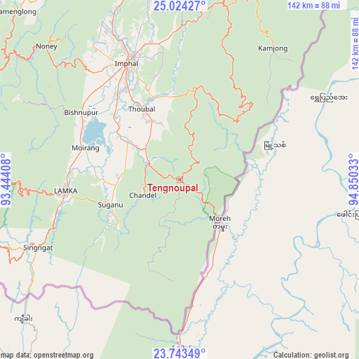
| Upper-left | 25.02427°, | 93.44408° |
| Center: | 24.3855°, | 94.1472° |
| Lower-right: | 23.74349°, | 94.85033° |
| Map W x H: | 142.4×142.4 km | = 88.5×88.5mi |
| max Lat: | 34.9274° ⇑40.1% North |
| Tengnoupal: | 24.3855° |
| min Lat: | ⇓59.9% South 8.09008° |
| min Long | Tengnoupal | max Long |
| 68.82655° | 94.1472° | 96.81° |
| W 98.9%⇐ | ⇒1.1% E |
Elevation
Elevation of Tengnoupal is 1388 m = 4554 ft, and this is 1092.4 m = 3584 ft above average elevation for this country.
| Max E: |
3681 m = 12077 ft | 2.5% |
| Tengnoupal | 1388 m 4554 ft | |
| Avg. | 295.6 m = 970 ft | |
Min E: |
1 m = 3 ft | 97.5% |
See also: India elevation on elevation.city.
Geographical zone
Tengnoupal is located in North temperate zone (between Tropic of Cancer and the Arctic Circle). Distance of this Northern Tropic circle is 105.5 km =65.6 mi to South.| Distance of | km | miles | from Tengnoupal |
|---|---|---|---|
| North Pole | 7295.6 | 4533.3 | to North |
| Arctic Circle | 4689.8 | 2914.1 | to North |
| Tropic Cancer | 105.5 | 65.6 | to South |
| Equator | 2711.4 | 1684.8 | to South |


Nearby cities:
15 places around Tengnoupal: (largest is in red/bold)
• Bishnupur
47.4 km =29.5 mi,  304°
304°
• Chandel
15.8 km =9.8 mi,  246°
246°
• Churāchāndpur
48.7 km =30.3 mi,  263°
263°
• Imphal
51.3 km =31.9 mi,  336°
336°
• Jiribam
113.7 km =70.6 mi,  294°
294°
• Kakching
21 km =13 mi,  306°
306°
• Kamjong
64.4 km =40 mi,  35°
35°
• Kāngpokpi
87.1 km =54.1 mi,  348°
348°
• Lakhipur
123.7 km =76.9 mi, 291°
• Mayāng Imphāl
36.2 km =22.5 mi, 313°
• Moirāng
39.4 km =24.5 mi, 288°
• Pherzawl
98.1 km =61 mi, 261°
• Thoubāl
32 km =19.9 mi,  331°
331°
• Wāngjing
24.2 km =15 mi, 339°
• Yairipok
34 km =21.1 mi, 342°
Sources, notices
• [Note1] Compared only with cities in India existing in our database
• [Src1] Map data: © OpenStreetMap contributors (CC-BY-SA)
• [Src2] Other city data from geonames.org with taken over terms of usage.
• [Src3] Geographical zone / Annual Mean Temperature by Robert A. Rohde @ Wikipedia
