Kohima geodata
Kohima (Nagaland) is a seat of a first-order administrative division; located in India in Asia/Kolkata (GMT+5.5) time zone. With population of 92,113 people, there are 484 cities with bigger population in this country. Compared to other cities in India, 68.3% of cities are located further ↓South; 98.8% of cities are located further ←West and 97.6% of cities have lower elevation than Kohima. Note1


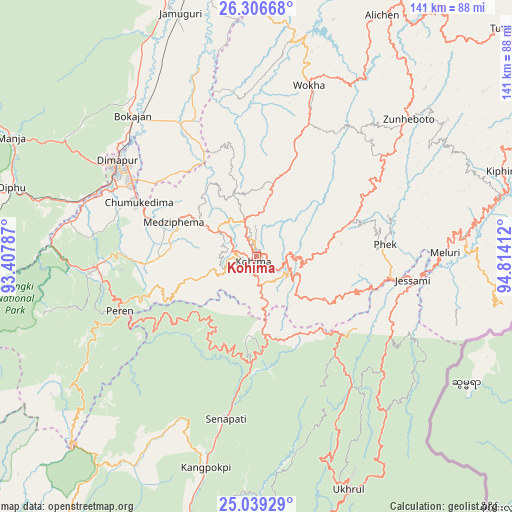
Kohima GPS coordinates[2]
25° 40' 28.812" North, 94° 6' 39.564" East
| Map corner | latitude | longitude |
|---|---|---|
| Upper-left | 26.30668°, | 93.40787° |
| Center: | 25.67467°, | 94.11099° |
| Lower-right: | 25.03929°, | 94.81412° |
| Map W x H: | 140.9×140.9 km | = 87.6×87.6mi |
| max Lat: | 34.9274° ⇑31.7% North |
| Kohima: | 25.67467° |
| min Lat: | ⇓68.3% South 8.09008° |
| min Long | Kohima | max Long |
| 68.82655° | 94.11099° | 96.81° |
| W 98.8%⇐ | ⇒1.2% E |
Elevation
Elevation of Kohima is 1463 m = 4800 ft, and this is 1167.4 m = 3830 ft above average elevation for this country.
| Max E: |
3681 m = 12077 ft | 2.4% |
| Kohima | 1463 m 4800 ft | |
| Avg. | 295.6 m = 970 ft | |
Min E: |
1 m = 3 ft | 97.6% |
See also: Kohima elevation on elevation.city.
Geographical zone
Kohima is located in North temperate zone (between Tropic of Cancer and the Arctic Circle). Distance of this Northern Tropic circle is 248.8 km =154.6 mi to South.| Distance of | km | miles | from Kohima |
|---|---|---|---|
| North Pole | 7152.3 | 4444.2 | to North |
| Arctic Circle | 4546.4 | 2825 | to North |
| Tropic Cancer | 248.8 | 154.6 | to South |
| Equator | 2854.8 | 1773.9 | to South |


Nearby cities:
15 places around Kohima: (largest is in red/bold)
• Barpathār
71.6 km =44.5 mi,  341°
341°
• Bokajān
50.9 km =31.6 mi,  319°
319°
• Dimāpur
47 km =29.2 mi,  304°
304°
• Diphu
70.6 km =43.9 mi,  285°
285°
• Golāghāt
94.3 km =58.6 mi,  350°
350°
• Imphal
97.8 km =60.8 mi,  189°
189°
• Kamjong
99.5 km =61.8 mi,  155°
155°
• Kāngpokpi
59.7 km =37.1 mi, 193°
• Lumding Railway Colony
94.6 km =58.8 mi,  275°
275°
• Mokokchūng
83 km =51.6 mi,  29°
29°
• Phek
39 km =24.2 mi,  91°
91°
• Titābar
103.5 km =64.3 mi,  5°
5°
• Tuensang
97.1 km =60.3 mi,  47°
47°
• Wokha
49.2 km =30.6 mi,  17°
17°
• Zunheboto
52 km =32.3 mi, 51°
Sources, notices
• [Note1] Compared only with cities in India existing in our database
• [Src1] Map data: © OpenStreetMap contributors (CC-BY-SA)
• [Src2] Other city data from geonames.org with taken over terms of usage.
• [Src3] Geographical zone / Annual Mean Temperature by Robert A. Rohde @ Wikipedia
