Kalamnūri geodata
Kalamnūri (Maharashtra) is a populated place; located in India in Asia/Kolkata (GMT+5.5) time zone. With population of 22,708 people, there are 1856 cities with bigger population in this country. Compared to other cities in India, 66.4% of cities are located further ↑North; 59.6% of cities are located further →East and 80.1% of cities have lower elevation than Kalamnūri. Note1


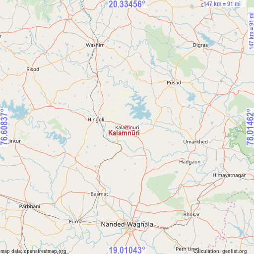
Kalamnūri GPS coordinates[2]
19° 40' 25.896" North, 77° 18' 41.364" East
| Map corner | latitude | longitude |
|---|---|---|
| Upper-left | 20.33456°, | 76.60837° |
| Center: | 19.67386°, | 77.31149° |
| Lower-right: | 19.01043°, | 78.01462° |
| Map W x H: | 147.2×147.2 km | = 91.5×91.5mi |
| max Lat: | 34.9274° ⇑66.4% North |
| Kalamnūri: | 19.67386° |
| min Lat: | ⇓33.6% South 8.09008° |
| min Long | Kalamnūri | max Long |
| 68.82655° | 77.31149° | 96.81° |
| W 40.4%⇐ | ⇒59.6% E |
Elevation
Elevation of Kalamnūri is 462 m = 1516 ft, and this is 166.4 m = 546 ft above average elevation for this country.
| Max E: |
3681 m = 12077 ft | 19.9% |
| Kalamnūri | 462 m 1516 ft | |
| Avg. | 295.6 m = 970 ft | |
Min E: |
1 m = 3 ft | 80.1% |
See also: India elevation on elevation.city.
Geographical zone
Kalamnūri is located in North Torrid zone (between Equator and Tropic of Cancer). Distance of this Northern Tropic circle is 418.4 km =260 mi to North.| Distance of | km | miles | from Kalamnūri |
|---|---|---|---|
| North Pole | 7819.5 | 4858.8 | to North |
| Arctic Circle | 5213.6 | 3239.6 | to North |
| Tropic Cancer | 418.4 | 260 | to North |
| Equator | 2187.5 | 1359.2 | to South |


Nearby cities:
15 places around Kalamnūri: (largest is in red/bold)
• Anshing
40.8 km =25.4 mi,  0°
0°
• Basmat
41.6 km =25.8 mi,  202°
202°
• Digras
64 km =39.8 mi,  41°
41°
• Hadgāon
41.4 km =25.7 mi,  118°
118°
• Hingoli
18.3 km =11.4 mi,  284°
284°
• Jintūr
65.7 km =40.8 mi,  263°
263°
• Mangrūl Pīr
71.2 km =44.2 mi, 2°
• Mudkhed
60.9 km =37.8 mi,  160°
160°
• Nanded
57.1 km =35.5 mi,  179°
179°
• Parbhani
72.4 km =45 mi,  231°
231°
• Pusad
38.5 km =23.9 mi,  46°
46°
• Pūrna
62.4 km =38.8 mi,  208°
208°
• Risod
64.3 km =40 mi,  301°
301°
• Umarkhed
40.3 km =25 mi,  101°
101°
• Wāshīm
52.1 km =32.4 mi,  339°
339°
Sources, notices
• [Note1] Compared only with cities in India existing in our database
• [Src1] Map data: © OpenStreetMap contributors (CC-BY-SA)
• [Src2] Other city data from geonames.org with taken over terms of usage.
• [Src3] Geographical zone / Annual Mean Temperature by Robert A. Rohde @ Wikipedia
