Hingoli geodata
Hingoli (Maharashtra) is a populated place; located in India in Asia/Kolkata (GMT+5.5) time zone. With population of 75,878 people, there are 580 cities with bigger population in this country. Compared to other cities in India, 66.2% of cities are located further ↑North; 61.5% of cities are located further →East and 79.9% of cities have lower elevation than Hingoli. Note1


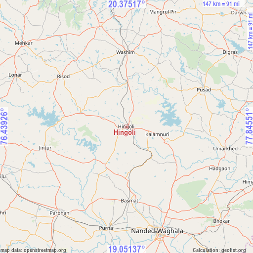
Hingoli GPS coordinates[2]
19° 42' 52.704" North, 77° 8' 32.568" East
| Map corner | latitude | longitude |
|---|---|---|
| Upper-left | 20.37517°, | 76.43926° |
| Center: | 19.71464°, | 77.14238° |
| Lower-right: | 19.05137°, | 77.84551° |
| Map W x H: | 147.2×147.2 km | = 91.5×91.5mi |
| max Lat: | 34.9274° ⇑66.2% North |
| Hingoli: | 19.71464° |
| min Lat: | ⇓33.8% South 8.09008° |
| min Long | Hingoli | max Long |
| 68.82655° | 77.14238° | 96.81° |
| W 38.5%⇐ | ⇒61.5% E |
Elevation
Elevation of Hingoli is 458 m = 1503 ft, and this is 162.4 m = 533 ft above average elevation for this country.
| Max E: |
3681 m = 12077 ft | 20.1% |
| Hingoli | 458 m 1503 ft | |
| Avg. | 295.6 m = 970 ft | |
Min E: |
1 m = 3 ft | 79.9% |
See also: Hingoli elevation on elevation.city.
Geographical zone
Hingoli is located in North Torrid zone (between Equator and Tropic of Cancer). Distance of this Northern Tropic circle is 413.9 km =257.2 mi to North.| Distance of | km | miles | from Hingoli |
|---|---|---|---|
| North Pole | 7815 | 4856 | to North |
| Arctic Circle | 5209.1 | 3236.8 | to North |
| Tropic Cancer | 413.9 | 257.2 | to North |
| Equator | 2192.1 | 1362.1 | to South |


Nearby cities:
15 places around Hingoli: (largest is in red/bold)
• Anshing
40.5 km =25.2 mi,  26°
26°
• Basmat
42.9 km =26.7 mi,  177°
177°
• Hadgāon
59.3 km =36.8 mi,  114°
114°
• Jintūr
49 km =30.4 mi,  256°
256°
• Kalamnūri
18.3 km =11.4 mi,  104°
104°
• Lonār
71.7 km =44.6 mi,  294°
294°
• Mangrūl Pīr
69.8 km =43.4 mi,  17°
17°
• Mudkhed
72.7 km =45.2 mi,  148°
148°
• Nanded
64.2 km =39.9 mi,  163°
163°
• Parbhani
63.1 km =39.2 mi,  218°
218°
• Pusad
50.6 km =31.4 mi,  64°
64°
• Pūrna
60.5 km =37.6 mi,  191°
191°
• Risod
47.1 km =29.3 mi,  308°
308°
• Umarkhed
58.6 km =36.4 mi, 102°
• Wāshīm
44.1 km =27.4 mi,  358°
358°
Sources, notices
• [Note1] Compared only with cities in India existing in our database
• [Src1] Map data: © OpenStreetMap contributors (CC-BY-SA)
• [Src2] Other city data from geonames.org with taken over terms of usage.
• [Src3] Geographical zone / Annual Mean Temperature by Robert A. Rohde @ Wikipedia
