Naldurg geodata
Naldurg (Maharashtra) is a populated place; located in India in Asia/Kolkata (GMT+5.5) time zone. With population of 17,261 people, there are 2261 cities with bigger population in this country. Compared to other cities in India, 72.2% of cities are located further ↑North; 70.8% of cities are located further →East and 86.5% of cities have lower elevation than Naldurg. Note1


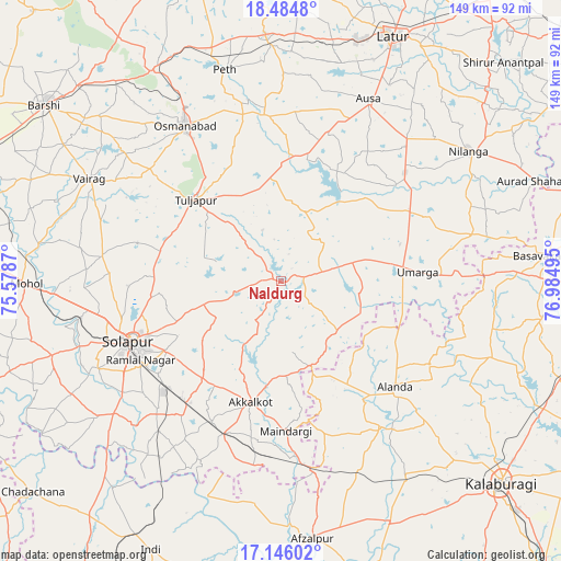
Naldurg GPS coordinates[2]
17° 49' 0.012" North, 76° 16' 54.552" East
| Map corner | latitude | longitude |
|---|---|---|
| Upper-left | 18.4848°, | 75.5787° |
| Center: | 17.81667°, | 76.28182° |
| Lower-right: | 17.14602°, | 76.98495° |
| Map W x H: | 148.9×148.9 km | = 92.5×92.5mi |
| max Lat: | 34.9274° ⇑72.2% North |
| Naldurg: | 17.81667° |
| min Lat: | ⇓27.8% South 8.09008° |
| min Long | Naldurg | max Long |
| 68.82655° | 76.28182° | 96.81° |
| W 29.2%⇐ | ⇒70.8% E |
Elevation
Elevation of Naldurg is 568 m = 1864 ft, and this is 272.4 m = 894 ft above average elevation for this country.
| Max E: |
3681 m = 12077 ft | 13.5% |
| Naldurg | 568 m 1864 ft | |
| Avg. | 295.6 m = 970 ft | |
Min E: |
1 m = 3 ft | 86.5% |
See also: India elevation on elevation.city.
Geographical zone
Naldurg is located in North Torrid zone (between Equator and Tropic of Cancer). Distance of this Northern Tropic circle is 624.9 km =388.3 mi to North.| Distance of | km | miles | from Naldurg |
|---|---|---|---|
| North Pole | 8026 | 4987.1 | to North |
| Arctic Circle | 5420.1 | 3367.9 | to North |
| Tropic Cancer | 624.9 | 388.3 | to North |
| Equator | 1981 | 1230.9 | to South |


Nearby cities:
15 places around Naldurg: (largest is in red/bold)
• Afzalpur
69.1 km =42.9 mi,  173°
173°
• Akalkot
33.4 km =20.8 mi,  193°
193°
• Aland
41.4 km =25.7 mi,  132°
132°
• Ausa
53.1 km =33 mi,  25°
25°
• Basavakalyān
71 km =44.1 mi,  84°
84°
• Dudhani
51.8 km =32.2 mi, 169°
• Kāti
44.6 km =27.7 mi,  291°
291°
• Latur
71.3 km =44.3 mi, 25°
• Maindargi
40 km =24.9 mi,  178°
178°
• Moram
20.3 km =12.6 mi,  99°
99°
• Nilanga
60 km =37.3 mi,  56°
56°
• Osmanabad
48 km =29.8 mi,  327°
327°
• Solāpur
42.5 km =26.4 mi,  247°
247°
• Tuljāpur
30.9 km =19.2 mi,  313°
313°
• Umarga
36.2 km =22.5 mi,  86°
86°
Sources, notices
• [Note1] Compared only with cities in India existing in our database
• [Src1] Map data: © OpenStreetMap contributors (CC-BY-SA)
• [Src2] Other city data from geonames.org with taken over terms of usage.
• [Src3] Geographical zone / Annual Mean Temperature by Robert A. Rohde @ Wikipedia
