Maindargi geodata
Maindargi (Maharashtra) is a populated place; located in India in Asia/Kolkata (GMT+5.5) time zone. With population of 11,444 people, there are 2781 cities with bigger population in this country. Compared to other cities in India, 73.5% of cities are located further ↑North; 70.7% of cities are located further →East and 79.4% of cities have lower elevation than Maindargi. Note1


Maindargi GPS coordinates[2]
17° 27' 26.604" North, 76° 17' 35.52" East
| Map corner | latitude | longitude |
|---|---|---|
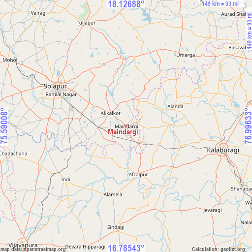
| Upper-left | 18.12688°, | 75.59008° |
| Center: | 17.45739°, | 76.2932° |
| Lower-right: | 16.78543°, | 76.99633° |
| Map W x H: | 149.2×149.2 km | = 92.7×92.7mi |
| max Lat: | 34.9274° ⇑73.5% North |
| Maindargi: | 17.45739° |
| min Lat: | ⇓26.5% South 8.09008° |
| min Long | Maindargi | max Long |
| 68.82655° | 76.2932° | 96.81° |
| W 29.3%⇐ | ⇒70.7% E |
Elevation
Elevation of Maindargi is 449 m = 1473 ft, and this is 153.4 m = 503 ft above average elevation for this country.
| Max E: |
3681 m = 12077 ft | 20.6% |
| Maindargi | 449 m 1473 ft | |
| Avg. | 295.6 m = 970 ft | |
Min E: |
1 m = 3 ft | 79.4% |
See also: India elevation on elevation.city.
Geographical zone
Maindargi is located in North Torrid zone (between Equator and Tropic of Cancer). Distance of this Northern Tropic circle is 664.8 km =413.1 mi to North.| Distance of | km | miles | from Maindargi |
|---|---|---|---|
| North Pole | 8066 | 5012 | to North |
| Arctic Circle | 5460.1 | 3392.7 | to North |
| Tropic Cancer | 664.8 | 413.1 | to North |
| Equator | 1941.1 | 1206.1 | to South |


Nearby cities:
15 places around Maindargi: (largest is in red/bold)
• Afzalpur
29.5 km =18.3 mi,  166°
166°
• Akalkot
11.9 km =7.4 mi,  309°
309°
• Aland
31.5 km =19.6 mi,  67°
67°
• Dudhani
13.5 km =8.4 mi,  144°
144°
• Gulbarga
59.3 km =36.8 mi,  103°
103°
• Indi
47.7 km =29.6 mi,  229°
229°
• Jevargi
70.9 km =44.1 mi,  134°
134°
• Kāti
70.5 km =43.8 mi,  322°
322°
• Moram
41.3 km =25.7 mi,  27°
27°
• Naldurg
40 km =24.9 mi,  358°
358°
• Shāhābād
78 km =48.5 mi,  117°
117°
• Sindgi
60.2 km =37.4 mi,  186°
186°
• Solāpur
47 km =29.2 mi,  300°
300°
• Tuljāpur
65.6 km =40.8 mi,  338°
338°
• Umarga
54.9 km =34.1 mi,  39°
39°
Sources, notices
• [Note1] Compared only with cities in India existing in our database
• [Src1] Map data: © OpenStreetMap contributors (CC-BY-SA)
• [Src2] Other city data from geonames.org with taken over terms of usage.
• [Src3] Geographical zone / Annual Mean Temperature by Robert A. Rohde @ Wikipedia
