Akalkot geodata
Akalkot (Maharashtra) is a populated place; located in India in Asia/Kolkata (GMT+5.5) time zone. With population of 39,226 people, there are 1124 cities with bigger population in this country. Compared to other cities in India, 73.2% of cities are located further ↑North; 71.6% of cities are located further →East and 80.9% of cities have lower elevation than Akalkot. Note1


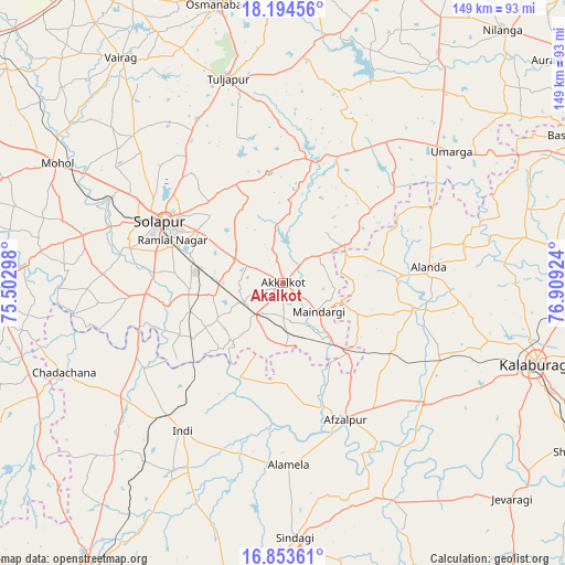
Akalkot GPS coordinates[2]
17° 31' 31.152" North, 76° 12' 21.996" East
| Map corner | latitude | longitude |
|---|---|---|
| Upper-left | 18.19456°, | 75.50298° |
| Center: | 17.52532°, | 76.20611° |
| Lower-right: | 16.85361°, | 76.90924° |
| Map W x H: | 149.1×149.1 km | = 92.6×92.6mi |
| max Lat: | 34.9274° ⇑73.2% North |
| Akalkot: | 17.52532° |
| min Lat: | ⇓26.8% South 8.09008° |
| min Long | Akalkot | max Long |
| 68.82655° | 76.20611° | 96.81° |
| W 28.4%⇐ | ⇒71.6% E |
Elevation
Elevation of Akalkot is 471 m = 1545 ft, and this is 175.4 m = 575 ft above average elevation for this country.
| Max E: |
3681 m = 12077 ft | 19.1% |
| Akalkot | 471 m 1545 ft | |
| Avg. | 295.6 m = 970 ft | |
Min E: |
1 m = 3 ft | 80.9% |
See also: India elevation on elevation.city.
Geographical zone
Akalkot is located in North Torrid zone (between Equator and Tropic of Cancer). Distance of this Northern Tropic circle is 657.3 km =408.4 mi to North.| Distance of | km | miles | from Akalkot |
|---|---|---|---|
| North Pole | 8058.4 | 5007.3 | to North |
| Arctic Circle | 5452.5 | 3388 | to North |
| Tropic Cancer | 657.3 | 408.4 | to North |
| Equator | 1948.6 | 1210.8 | to South |


Nearby cities:
15 places around Akalkot: (largest is in red/bold)
• Afzalpur
39.7 km =24.7 mi,  155°
155°
• Aland
38.7 km =24 mi,  83°
83°
• Dudhani
25.2 km =15.7 mi,  137°
137°
• Gulbarga
70.2 km =43.6 mi,  107°
107°
• Indi
47.1 km =29.3 mi,  214°
214°
• Jevargi
82.8 km =51.4 mi,  133°
133°
• Kāti
59 km =36.7 mi,  325°
325°
• Maindargi
11.9 km =7.4 mi, 129°
• Moram
40.5 km =25.2 mi,  43°
43°
• Naldurg
33.4 km =20.8 mi,  13°
13°
• Osmanabad
75.1 km =46.7 mi,  346°
346°
• Sindgi
67.5 km =41.9 mi,  177°
177°
• Solāpur
35.3 km =21.9 mi,  297°
297°
• Tuljāpur
55.6 km =34.5 mi,  344°
344°
• Umarga
56.3 km =35 mi,  51°
51°
Sources, notices
• [Note1] Compared only with cities in India existing in our database
• [Src1] Map data: © OpenStreetMap contributors (CC-BY-SA)
• [Src2] Other city data from geonames.org with taken over terms of usage.
• [Src3] Geographical zone / Annual Mean Temperature by Robert A. Rohde @ Wikipedia
