Pindwāra geodata
Pindwāra (Rajasthan) is a populated place; located in India in Asia/Kolkata (GMT+5.5) time zone. With population of 23,229 people, there are 1822 cities with bigger population in this country. Compared to other cities in India, 62.4% of cities are located further ↓South; 94.4% of cities are located further →East and 74.1% of cities have lower elevation than Pindwāra. Note1


Pindwāra GPS coordinates[2]
24° 47' 50.964" North, 73° 3' 18.18" East
| Map corner | latitude | longitude |
|---|---|---|
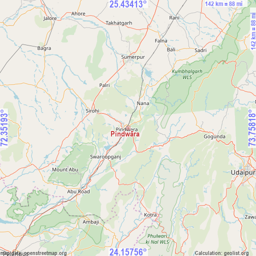
| Upper-left | 25.43413°, | 72.35193° |
| Center: | 24.79749°, | 73.05505° |
| Lower-right: | 24.15756°, | 73.75818° |
| Map W x H: | 141.9×141.9 km | = 88.2×88.2mi |
| max Lat: | 34.9274° ⇑37.6% North |
| Pindwāra: | 24.79749° |
| min Lat: | ⇓62.4% South 8.09008° |
| min Long | Pindwāra | max Long |
| 68.82655° | 73.05505° | 96.81° |
| W 5.6%⇐ | ⇒94.4% E |
Elevation
Elevation of Pindwāra is 375 m = 1230 ft, and this is 79.4 m = 260 ft above average elevation for this country.
| Max E: |
3681 m = 12077 ft | 25.9% |
| Pindwāra | 375 m 1230 ft | |
| Avg. | 295.6 m = 970 ft | |
Min E: |
1 m = 3 ft | 74.1% |
See also: India elevation on elevation.city.
Geographical zone
Pindwāra is located in North temperate zone (between Tropic of Cancer and the Arctic Circle). Distance of this Northern Tropic circle is 151.3 km =94 mi to South.| Distance of | km | miles | from Pindwāra |
|---|---|---|---|
| North Pole | 7249.8 | 4504.8 | to North |
| Arctic Circle | 4644 | 2885.6 | to North |
| Tropic Cancer | 151.3 | 94 | to South |
| Equator | 2757.2 | 1713.2 | to South |


Nearby cities:
15 places around Pindwāra: (largest is in red/bold)
• Bhīnmāl
82.2 km =51.1 mi,  285°
285°
• Bāli
50.4 km =31.3 mi,  28°
28°
• Jalor
75.3 km =46.8 mi,  324°
324°
• Khedbrahma
85.4 km =53.1 mi,  180°
180°
• Nāthdwāra
79.1 km =49.2 mi,  78°
78°
• Pālanpur
93.5 km =58.1 mi,  221°
221°
• Rājsamand
88.6 km =55.1 mi,  69°
69°
• Rāni
66.6 km =41.4 mi,  22°
22°
• Sheoganj
38 km =23.6 mi,  1°
1°
• Sirohi
23.2 km =14.4 mi,  295°
295°
• Sādri
58.9 km =36.6 mi,  42°
42°
• Takhatgarh
58.6 km =36.4 mi,  355°
355°
• Udaipur
70.6 km =43.9 mi,  109°
109°
• Ābu
40.9 km =25.4 mi,  236°
236°
• Ābu Road
44.8 km =27.8 mi, 218°
Sources, notices
• [Note1] Compared only with cities in India existing in our database
• [Src1] Map data: © OpenStreetMap contributors (CC-BY-SA)
• [Src2] Other city data from geonames.org with taken over terms of usage.
• [Src3] Geographical zone / Annual Mean Temperature by Robert A. Rohde @ Wikipedia
