Sheoganj geodata
Sheoganj (Rajasthan) is a populated place; located in India in Asia/Kolkata (GMT+5.5) time zone. With population of 26,804 people, there are 1593 cities with bigger population in this country. Compared to other cities in India, 64% of cities are located further ↓South; 94.4% of cities are located further →East and 63.4% of cities have lower elevation than Sheoganj. Note1


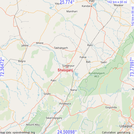
Sheoganj GPS coordinates[2]
25° 8' 20.94" North, 73° 4' 4.224" East
| Map corner | latitude | longitude |
|---|---|---|
| Upper-left | 25.774°, | 72.36472° |
| Center: | 25.13915°, | 73.06784° |
| Lower-right: | 24.50098°, | 73.77097° |
| Map W x H: | 141.5×141.5 km | = 87.9×87.9mi |
| max Lat: | 34.9274° ⇑36% North |
| Sheoganj: | 25.13915° |
| min Lat: | ⇓64% South 8.09008° |
| min Long | Sheoganj | max Long |
| 68.82655° | 73.06784° | 96.81° |
| W 5.6%⇐ | ⇒94.4% E |
Elevation
Elevation of Sheoganj is 274 m = 899 ft, and this is 21.6 m = 71 ft below average elevation for this country.
| Max E: |
3681 m = 12077 ft | 36.6% |
| Avg. | 295.6 m = 970 ft | |
| Sheoganj | 274 m = 899 ft | |
Min E: |
1 m = 3 ft | 63.4% |
See also: India elevation on elevation.city.
Geographical zone
Sheoganj is located in North temperate zone (between Tropic of Cancer and the Arctic Circle). Distance of this Northern Tropic circle is 189.3 km =117.6 mi to South.| Distance of | km | miles | from Sheoganj |
|---|---|---|---|
| North Pole | 7211.9 | 4481.3 | to North |
| Arctic Circle | 4606 | 2862 | to North |
| Tropic Cancer | 189.3 | 117.6 | to South |
| Equator | 2795.2 | 1736.9 | to South |


Nearby cities:
15 places around Sheoganj: (largest is in red/bold)
• Amet
88.3 km =54.9 mi,  77°
77°
• Bhīnmāl
81.7 km =50.8 mi,  259°
259°
• Bāli
23.4 km =14.5 mi,  73°
73°
• Jalor
50.9 km =31.6 mi,  296°
296°
• Nāthdwāra
79.4 km =49.3 mi,  106°
106°
• Pindwāra
38 km =23.6 mi,  181°
181°
• Pāli
75 km =46.6 mi,  20°
20°
• Rājsamand
82.1 km =51 mi,  95°
95°
• Rāni
33.7 km =20.9 mi,  45°
45°
• Sirohi
35.6 km =22.1 mi,  218°
218°
• Siwāna
86.3 km =53.6 mi,  311°
311°
• Sādri
39.1 km =24.3 mi, 82°
• Takhatgarh
21.3 km =13.2 mi,  342°
342°
• Ābu
70.2 km =43.6 mi,  210°
210°
• Ābu Road
78.8 km =49 mi,  201°
201°
Sources, notices
• [Note1] Compared only with cities in India existing in our database
• [Src1] Map data: © OpenStreetMap contributors (CC-BY-SA)
• [Src2] Other city data from geonames.org with taken over terms of usage.
• [Src3] Geographical zone / Annual Mean Temperature by Robert A. Rohde @ Wikipedia
