Bāli geodata
Bāli (Rajasthan) is a populated place; located in India in Asia/Kolkata (GMT+5.5) time zone. With population of 19,259 people, there are 2105 cities with bigger population in this country. Compared to other cities in India, 64.5% of cities are located further ↓South; 93.5% of cities are located further →East and 66.6% of cities have lower elevation than Bāli. Note1


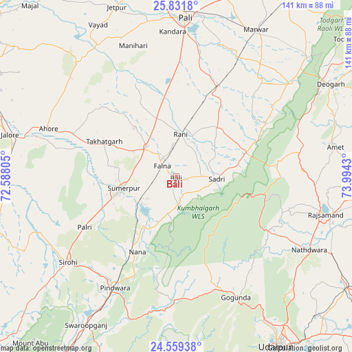
Bāli GPS coordinates[2]
25° 11' 50.1" North, 73° 17' 28.212" East
| Map corner | latitude | longitude |
|---|---|---|
| Upper-left | 25.8318°, | 72.58805° |
| Center: | 25.19725°, | 73.29117° |
| Lower-right: | 24.55938°, | 73.9943° |
| Map W x H: | 141.5×141.5 km | = 87.9×87.9mi |
| max Lat: | 34.9274° ⇑35.5% North |
| Bāli: | 25.19725° |
| min Lat: | ⇓64.5% South 8.09008° |
| min Long | Bāli | max Long |
| 68.82655° | 73.29117° | 96.81° |
| W 6.5%⇐ | ⇒93.5% E |
Elevation
Elevation of Bāli is 299 m = 981 ft, and this is 3.4 m = 11 ft above average elevation for this country.
| Max E: |
3681 m = 12077 ft | 33.4% |
| Bāli | 299 m 981 ft | |
| Avg. | 295.6 m = 970 ft | |
Min E: |
1 m = 3 ft | 66.6% |
See also: India elevation on elevation.city.
Geographical zone
Bāli is located in North temperate zone (between Tropic of Cancer and the Arctic Circle). Distance of this Northern Tropic circle is 195.8 km =121.7 mi to South.| Distance of | km | miles | from Bāli |
|---|---|---|---|
| North Pole | 7205.4 | 4477.2 | to North |
| Arctic Circle | 4599.5 | 2858 | to North |
| Tropic Cancer | 195.8 | 121.7 | to South |
| Equator | 2801.7 | 1740.9 | to South |


Nearby cities:
15 places around Bāli: (largest is in red/bold)
• Amet
65 km =40.4 mi,  79°
79°
• Devgarh
71.9 km =44.7 mi,  59°
59°
• Jalor
69.9 km =43.4 mi,  283°
283°
• Nāthdwāra
60.9 km =37.8 mi,  118°
118°
• Pindwāra
50.4 km =31.3 mi,  208°
208°
• Pāli
64.1 km =39.8 mi,  2°
2°
• Rājsamand
60.9 km =37.8 mi,  103°
103°
• Rāni
17.1 km =10.6 mi,  5°
5°
• Sheoganj
23.4 km =14.5 mi,  253°
253°
• Sirohi
56.3 km =35 mi,  232°
232°
• Sojat
89.2 km =55.4 mi,  24°
24°
• Sādri
16.3 km =10.1 mi,  94°
94°
• Takhatgarh
32 km =19.9 mi,  295°
295°
• Udaipur
80.2 km =49.8 mi,  147°
147°
• Ābu
88.6 km =55.1 mi,  220°
220°
Sources, notices
• [Note1] Compared only with cities in India existing in our database
• [Src1] Map data: © OpenStreetMap contributors (CC-BY-SA)
• [Src2] Other city data from geonames.org with taken over terms of usage.
• [Src3] Geographical zone / Annual Mean Temperature by Robert A. Rohde @ Wikipedia
