Oran geodata
Oran (Uttar Pradesh) is a populated place; located in India in Asia/Kolkata (GMT+5.5) time zone. With population of 6,495 people, there are 3249 cities with bigger population in this country. Compared to other cities in India, 65.8% of cities are located further ↓South; 71.8% of cities are located further ←West and 62.8% of cities have higher elevation than Oran. Note1


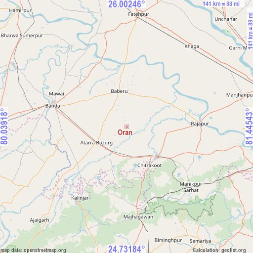
Oran GPS coordinates[2]
25° 22' 7.752" North, 80° 44' 32.28" East
| Map corner | latitude | longitude |
|---|---|---|
| Upper-left | 26.00246°, | 80.03918° |
| Center: | 25.36882°, | 80.7423° |
| Lower-right: | 24.73184°, | 81.44543° |
| Map W x H: | 141.3×141.3 km | = 87.8×87.8mi |
| max Lat: | 34.9274° ⇑34.2% North |
| Oran: | 25.36882° |
| min Lat: | ⇓65.8% South 8.09008° |
| min Long | Oran | max Long |
| 68.82655° | 80.7423° | 96.81° |
| W 71.8%⇐ | ⇒28.2% E |
Elevation
Elevation of Oran is 133 m = 436 ft, and this is 162.6 m = 533 ft below average elevation for this country.
| Max E: |
3681 m = 12077 ft | 62.8% |
| Avg. | 295.6 m = 970 ft | |
| Oran | 133 m = 436 ft | |
Min E: |
1 m = 3 ft | 37.2% |
See also: India elevation on elevation.city.
Geographical zone
Oran is located in North temperate zone (between Tropic of Cancer and the Arctic Circle). Distance of this Northern Tropic circle is 214.8 km =133.5 mi to South.| Distance of | km | miles | from Oran |
|---|---|---|---|
| North Pole | 7186.3 | 4465.4 | to North |
| Arctic Circle | 4580.4 | 2846.1 | to North |
| Tropic Cancer | 214.8 | 133.5 | to South |
| Equator | 2820.7 | 1752.7 | to South |


Nearby cities:
15 places around Oran: (largest is in red/bold)
• Atarra
19.5 km =12.1 mi,  241°
241°
• Baberu
20.2 km =12.6 mi,  349°
349°
• Bahua
53.7 km =33.4 mi, 347°
• Bisenda Buzurg
13 km =8.1 mi,  287°
287°
• Bānda
42.7 km =26.5 mi, 286°
• Chandla
64.4 km =40 mi, 239°
• Fatehpur
62.5 km =38.8 mi,  6°
6°
• Khāga
57.7 km =35.9 mi,  38°
38°
• Kishanpur
41.4 km =25.7 mi, 42°
• Mataundh
59.3 km =36.8 mi,  277°
277°
• Mānikpur
49.6 km =30.8 mi,  133°
133°
• Naraini
33.4 km =20.8 mi,  233°
233°
• Rājāpur
41.1 km =25.5 mi,  87°
87°
• Sirāthu
65.4 km =40.6 mi,  62°
62°
• Tindwāri
35.1 km =21.8 mi,  322°
322°
Sources, notices
• [Note1] Compared only with cities in India existing in our database
• [Src1] Map data: © OpenStreetMap contributors (CC-BY-SA)
• [Src2] Other city data from geonames.org with taken over terms of usage.
• [Src3] Geographical zone / Annual Mean Temperature by Robert A. Rohde @ Wikipedia
