Khāga geodata
Khāga (Uttar Pradesh) is a populated place; located in India in Asia/Kolkata (GMT+5.5) time zone. With population of 13,338 people, there are 2625 cities with bigger population in this country. Compared to other cities in India, 68.9% of cities are located further ↓South; 73.3% of cities are located further ←West and 65.8% of cities have higher elevation than Khāga. Note1


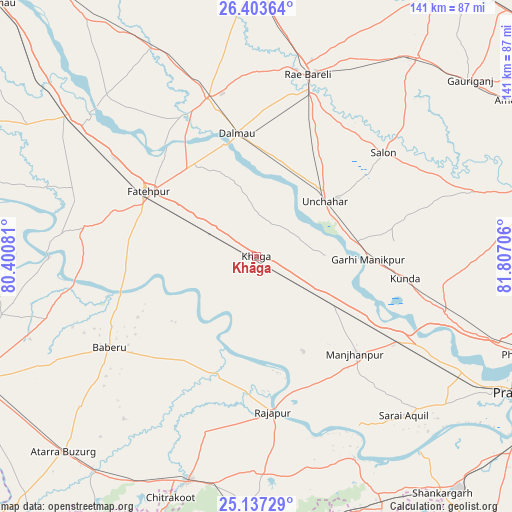
Khāga GPS coordinates[2]
25° 46' 19.74" North, 81° 6' 14.148" East
| Map corner | latitude | longitude |
|---|---|---|
| Upper-left | 26.40364°, | 80.40081° |
| Center: | 25.77215°, | 81.10393° |
| Lower-right: | 25.13729°, | 81.80706° |
| Map W x H: | 140.8×140.8 km | = 87.5×87.5mi |
| max Lat: | 34.9274° ⇑31.1% North |
| Khāga: | 25.77215° |
| min Lat: | ⇓68.9% South 8.09008° |
| min Long | Khāga | max Long |
| 68.82655° | 81.10393° | 96.81° |
| W 73.3%⇐ | ⇒26.7% E |
Elevation
Elevation of Khāga is 115 m = 377 ft, and this is 180.6 m = 593 ft below average elevation for this country.
| Max E: |
3681 m = 12077 ft | 65.8% |
| Avg. | 295.6 m = 970 ft | |
| Khāga | 115 m = 377 ft | |
Min E: |
1 m = 3 ft | 34.2% |
See also: India elevation on elevation.city.
Geographical zone
Khāga is located in North temperate zone (between Tropic of Cancer and the Arctic Circle). Distance of this Northern Tropic circle is 259.7 km =161.4 mi to South.| Distance of | km | miles | from Khāga |
|---|---|---|---|
| North Pole | 7141.5 | 4437.5 | to North |
| Arctic Circle | 4535.6 | 2818.3 | to North |
| Tropic Cancer | 259.7 | 161.4 | to South |
| Equator | 2865.6 | 1780.6 | to South |


Nearby cities:
15 places around Khāga: (largest is in red/bold)
• Baberu
47.2 km =29.3 mi,  237°
237°
• Bahua
48.8 km =30.3 mi,  278°
278°
• Bharwāri
45.4 km =28.2 mi,  121°
121°
• Dalmau
33.4 km =20.8 mi,  347°
347°
• Fatehpur
33.9 km =21.1 mi,  300°
300°
• Karārī
48.1 km =29.9 mi,  137°
137°
• Kishanpur
16.6 km =10.3 mi,  209°
209°
• Kunda
41.5 km =25.8 mi,  98°
98°
• Manjhanpur
38.3 km =23.8 mi,  134°
134°
• Oran
57.7 km =35.9 mi,  218°
218°
• Parshādepur
51.3 km =31.9 mi,  49°
49°
• Raebareli
52.6 km =32.7 mi,  14°
14°
• Rājāpur
43.1 km =26.8 mi,  173°
173°
• Salon
45.2 km =28.1 mi, 50°
• Sirāthu
25.9 km =16.1 mi, 123°
Sources, notices
• [Note1] Compared only with cities in India existing in our database
• [Src1] Map data: © OpenStreetMap contributors (CC-BY-SA)
• [Src2] Other city data from geonames.org with taken over terms of usage.
• [Src3] Geographical zone / Annual Mean Temperature by Robert A. Rohde @ Wikipedia
