Bhīnmāl geodata
Bhīnmāl (Rajasthan) is a populated place; located in India in Asia/Kolkata (GMT+5.5) time zone. With population of 42,863 people, there are 1030 cities with bigger population in this country. Compared to other cities in India, 63.4% of cities are located further ↓South; 97.1% of cities are located further →East and 59.1% of cities have higher elevation than Bhīnmāl. Note1


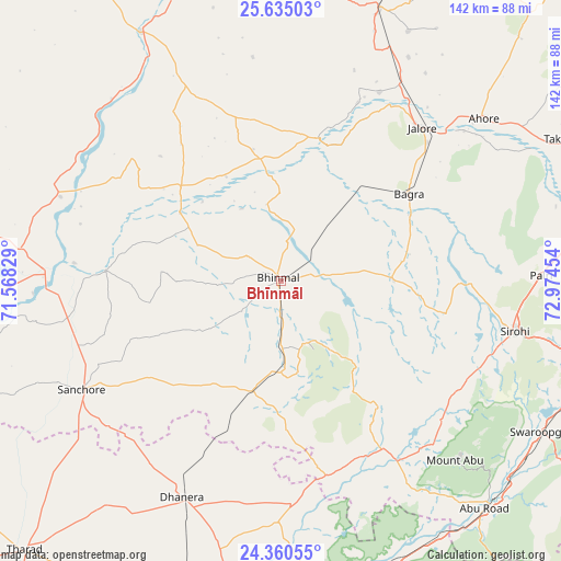
Bhīnmāl GPS coordinates[2]
24° 59' 57.984" North, 72° 16' 17.076" East
| Map corner | latitude | longitude |
|---|---|---|
| Upper-left | 25.63503°, | 71.56829° |
| Center: | 24.99944°, | 72.27141° |
| Lower-right: | 24.36055°, | 72.97454° |
| Map W x H: | 141.7×141.7 km | = 88×88mi |
| max Lat: | 34.9274° ⇑36.6% North |
| Bhīnmāl: | 24.99944° |
| min Lat: | ⇓63.4% South 8.09008° |
| min Long | Bhīnmāl | max Long |
| 68.82655° | 72.27141° | 96.81° |
| W 2.9%⇐ | ⇒97.1% E |
Elevation
Elevation of Bhīnmāl is 153 m = 502 ft, and this is 142.6 m = 468 ft below average elevation for this country.
| Max E: |
3681 m = 12077 ft | 59.1% |
| Avg. | 295.6 m = 970 ft | |
| Bhīnmāl | 153 m = 502 ft | |
Min E: |
1 m = 3 ft | 40.9% |
See also: Bhīnmāl elevation on elevation.city.
Geographical zone
Bhīnmāl is located in North temperate zone (between Tropic of Cancer and the Arctic Circle). Distance of this Northern Tropic circle is 173.8 km =108 mi to South.| Distance of | km | miles | from Bhīnmāl |
|---|---|---|---|
| North Pole | 7227.4 | 4490.9 | to North |
| Arctic Circle | 4621.5 | 2871.7 | to North |
| Tropic Cancer | 173.8 | 108 | to South |
| Equator | 2779.7 | 1727.2 | to South |


Nearby cities:
15 places around Bhīnmāl: (largest is in red/bold)
• Bālotra
92.7 km =57.6 mi,  358°
358°
• Dhanera
59.9 km =37.2 mi,  204°
204°
• Dīsa
83.2 km =51.7 mi,  186°
186°
• Jalor
51.8 km =32.2 mi,  41°
41°
• Pindwāra
82.2 km =51.1 mi,  105°
105°
• Pālanpur
93.6 km =58.2 mi,  169°
169°
• Samdari
95.6 km =59.4 mi,  18°
18°
• Sheoganj
81.7 km =50.8 mi,  79°
79°
• Sirohi
59.4 km =36.9 mi,  101°
101°
• Siwāna
74.1 km =46 mi,  11°
11°
• Sānchor
57.2 km =35.5 mi,  241°
241°
• Takhatgarh
82.1 km =51 mi,  64°
64°
• Tharād
93.6 km =58.2 mi,  224°
224°
• Ābu
63.7 km =39.6 mi,  135°
135°
• Ābu Road
77.4 km =48.1 mi, 138°
Sources, notices
• [Note1] Compared only with cities in India existing in our database
• [Src1] Map data: © OpenStreetMap contributors (CC-BY-SA)
• [Src2] Other city data from geonames.org with taken over terms of usage.
• [Src3] Geographical zone / Annual Mean Temperature by Robert A. Rohde @ Wikipedia
