Sānchor geodata
Sānchor (Rajasthan) is a populated place; located in India in Asia/Kolkata (GMT+5.5) time zone. With population of 29,022 people, there are 1493 cities with bigger population in this country. Compared to other cities in India, 62.1% of cities are located further ↓South; 97.7% of cities are located further →East and 76.3% of cities have higher elevation than Sānchor. Note1


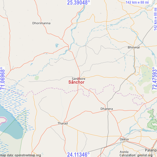
Sānchor GPS coordinates[2]
24° 45' 12.996" North, 71° 46' 22.08" East
| Map corner | latitude | longitude |
|---|---|---|
| Upper-left | 25.39048°, | 71.06968° |
| Center: | 24.75361°, | 71.7728° |
| Lower-right: | 24.11346°, | 72.47593° |
| Map W x H: | 142×142 km | = 88.2×88.2mi |
| max Lat: | 34.9274° ⇑37.9% North |
| Sānchor: | 24.75361° |
| min Lat: | ⇓62.1% South 8.09008° |
| min Long | Sānchor | max Long |
| 68.82655° | 71.7728° | 96.81° |
| W 2.3%⇐ | ⇒97.7% E |
Elevation
Elevation of Sānchor is 62 m = 203 ft, and this is 233.6 m = 766 ft below average elevation for this country.
| Max E: |
3681 m = 12077 ft | 76.3% |
| Avg. | 295.6 m = 970 ft | |
| Sānchor | 62 m = 203 ft | |
Min E: |
1 m = 3 ft | 23.7% |
See also: India elevation on elevation.city.
Geographical zone
Sānchor is located in North temperate zone (between Tropic of Cancer and the Arctic Circle). Distance of this Northern Tropic circle is 146.4 km =91 mi to South.| Distance of | km | miles | from Sānchor |
|---|---|---|---|
| North Pole | 7254.7 | 4507.9 | to North |
| Arctic Circle | 4648.8 | 2888.6 | to North |
| Tropic Cancer | 146.4 | 91 | to South |
| Equator | 2752.3 | 1710.2 | to South |


Nearby cities:
15 places around Sānchor: (largest is in red/bold)
• Bhīnmāl
57.2 km =35.5 mi,  61°
61°
• Bārmer
116.8 km =72.6 mi,  340°
340°
• Dhanera
37.1 km =23.1 mi,  136°
136°
• Dīsa
68.9 km =42.8 mi, 143°
• Jalor
107.4 km =66.7 mi,  52°
52°
• Kānodar
97 km =60.3 mi, 139°
• Pālanpur
93.4 km =58 mi,  133°
133°
• Pātan
106.7 km =66.3 mi,  160°
160°
• Rādhanpur
103.8 km =64.5 mi,  189°
189°
• Siddhapur
111 km =69 mi,  146°
146°
• Sirohi
109.5 km =68 mi,  82°
82°
• Tharād
42.5 km =26.4 mi,  200°
200°
• Un
96.3 km =59.8 mi,  180°
180°
• Ābu
97.1 km =60.3 mi,  100°
100°
• Ābu Road
106.4 km =66.1 mi,  106°
106°
Sources, notices
• [Note1] Compared only with cities in India existing in our database
• [Src1] Map data: © OpenStreetMap contributors (CC-BY-SA)
• [Src2] Other city data from geonames.org with taken over terms of usage.
• [Src3] Geographical zone / Annual Mean Temperature by Robert A. Rohde @ Wikipedia
