Rāni geodata
Rāni (Rajasthan) is a populated place; located in India in Asia/Kolkata (GMT+5.5) time zone. With population of 13,572 people, there are 2608 cities with bigger population in this country. Compared to other cities in India, 65.7% of cities are located further ↓South; 93.4% of cities are located further →East and 64.4% of cities have lower elevation than Rāni. Note1


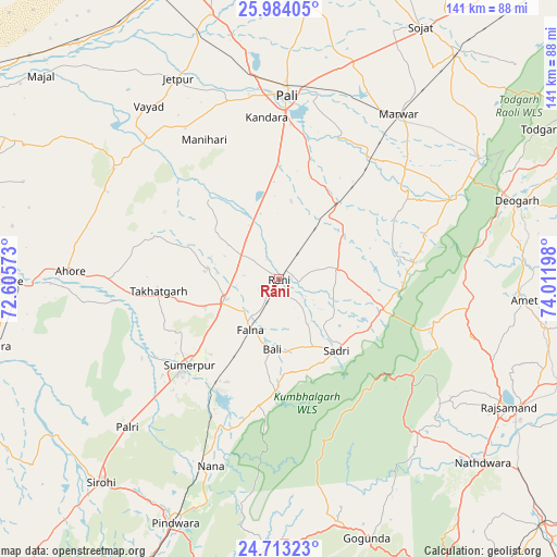
Rāni GPS coordinates[2]
25° 21' 1.116" North, 73° 18' 31.86" East
| Map corner | latitude | longitude |
|---|---|---|
| Upper-left | 25.98405°, | 72.60573° |
| Center: | 25.35031°, | 73.30885° |
| Lower-right: | 24.71323°, | 74.01198° |
| Map W x H: | 141.3×141.3 km | = 87.8×87.8mi |
| max Lat: | 34.9274° ⇑34.3% North |
| Rāni: | 25.35031° |
| min Lat: | ⇓65.7% South 8.09008° |
| min Long | Rāni | max Long |
| 68.82655° | 73.30885° | 96.81° |
| W 6.6%⇐ | ⇒93.4% E |
Elevation
Elevation of Rāni is 281 m = 922 ft, and this is 14.6 m = 48 ft below average elevation for this country.
| Max E: |
3681 m = 12077 ft | 35.6% |
| Avg. | 295.6 m = 970 ft | |
| Rāni | 281 m = 922 ft | |
Min E: |
1 m = 3 ft | 64.4% |
See also: India elevation on elevation.city.
Geographical zone
Rāni is located in North temperate zone (between Tropic of Cancer and the Arctic Circle). Distance of this Northern Tropic circle is 212.8 km =132.2 mi to South.| Distance of | km | miles | from Rāni |
|---|---|---|---|
| North Pole | 7188.4 | 4466.7 | to North |
| Arctic Circle | 4582.5 | 2847.4 | to North |
| Tropic Cancer | 212.8 | 132.2 | to South |
| Equator | 2818.7 | 1751.5 | to South |


Nearby cities:
15 places around Rāni: (largest is in red/bold)
• Amet
62.2 km =38.6 mi,  94°
94°
• Bāli
17.1 km =10.6 mi,  185°
185°
• Dariba
94.3 km =58.6 mi,  118°
118°
• Devgarh
63.2 km =39.3 mi,  72°
72°
• Jalor
69.7 km =43.3 mi,  269°
269°
• Nāthdwāra
69.2 km =43 mi,  131°
131°
• Pindwāra
66.6 km =41.4 mi,  202°
202°
• Pāli
47 km =29.2 mi,  1°
1°
• Rājsamand
65.3 km =40.6 mi, 118°
• Samdari
89.5 km =55.6 mi,  305°
305°
• Sheoganj
33.7 km =20.9 mi,  225°
225°
• Sirohi
69.2 km =43 mi,  222°
222°
• Sojat
73.3 km =45.5 mi,  29°
29°
• Sādri
23.4 km =14.5 mi,  141°
141°
• Takhatgarh
30.7 km =19.1 mi,  264°
264°
Sources, notices
• [Note1] Compared only with cities in India existing in our database
• [Src1] Map data: © OpenStreetMap contributors (CC-BY-SA)
• [Src2] Other city data from geonames.org with taken over terms of usage.
• [Src3] Geographical zone / Annual Mean Temperature by Robert A. Rohde @ Wikipedia
