Sarāi Ākil geodata
Sarāi Ākil (Uttar Pradesh) is a populated place; located in India in Asia/Kolkata (GMT+5.5) time zone. With population of 17,443 people, there are 2244 cities with bigger population in this country. Compared to other cities in India, 65.9% of cities are located further ↓South; 74.7% of cities are located further ←West and 66.8% of cities have higher elevation than Sarāi Ākil. Note1


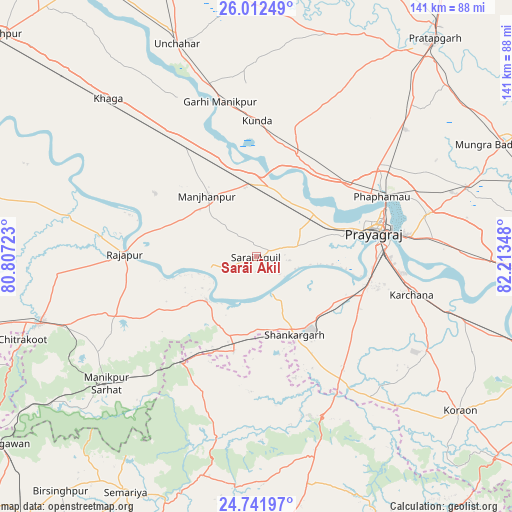
Sarāi Ākil GPS coordinates[2]
25° 22' 44.04" North, 81° 30' 37.26" East
| Map corner | latitude | longitude |
|---|---|---|
| Upper-left | 26.01249°, | 80.80723° |
| Center: | 25.3789°, | 81.51035° |
| Lower-right: | 24.74197°, | 82.21348° |
| Map W x H: | 141.3×141.3 km | = 87.8×87.8mi |
| max Lat: | 34.9274° ⇑34.1% North |
| Sarāi Ākil: | 25.3789° |
| min Lat: | ⇓65.9% South 8.09008° |
| min Long | Sarāi Ākil | max Long |
| 68.82655° | 81.51035° | 96.81° |
| W 74.7%⇐ | ⇒25.3% E |
Elevation
Elevation of Sarāi Ākil is 107 m = 351 ft, and this is 188.6 m = 619 ft below average elevation for this country.
| Max E: |
3681 m = 12077 ft | 66.8% |
| Avg. | 295.6 m = 970 ft | |
| Sarāi Ākil | 107 m = 351 ft | |
Min E: |
1 m = 3 ft | 33.2% |
See also: India elevation on elevation.city.
Geographical zone
Sarāi Ākil is located in North temperate zone (between Tropic of Cancer and the Arctic Circle). Distance of this Northern Tropic circle is 216 km =134.2 mi to South.| Distance of | km | miles | from Sarāi Ākil |
|---|---|---|---|
| North Pole | 7185.2 | 4464.7 | to North |
| Arctic Circle | 4579.3 | 2845.4 | to North |
| Tropic Cancer | 216 | 134.2 | to South |
| Equator | 2821.9 | 1753.4 | to South |


Nearby cities:
15 places around Sarāi Ākil: (largest is in red/bold)
• Allahābād
34.2 km =21.3 mi,  77°
77°
• Bharwāri
20.3 km =12.6 mi,  354°
354°
• Chail
13.3 km =8.3 mi,  66°
66°
• Jhūsi
40.2 km =25 mi, 80°
• Karārī
11.7 km =7.3 mi,  314°
314°
• Kotwa
43.2 km =26.8 mi,  206°
206°
• Kunda
37.6 km =23.4 mi,  0°
0°
• Manjhanpur
21.6 km =13.4 mi,  321°
321°
• Mau Aimma
54.3 km =33.7 mi,  49°
49°
• Mānikpur
54.4 km =33.8 mi,  229°
229°
• Rājāpur
36.1 km =22.4 mi,  271°
271°
• Shankargarh
24.4 km =15.2 mi,  153°
153°
• Sirāthu
35.1 km =21.8 mi,  326°
326°
• Sohāgi
47.9 km =29.8 mi,  157°
157°
• Teonthar
46.1 km =28.6 mi, 163°
Sources, notices
• [Note1] Compared only with cities in India existing in our database
• [Src1] Map data: © OpenStreetMap contributors (CC-BY-SA)
• [Src2] Other city data from geonames.org with taken over terms of usage.
• [Src3] Geographical zone / Annual Mean Temperature by Robert A. Rohde @ Wikipedia
