Jhūsi geodata
Jhūsi (Uttar Pradesh) is a populated place; located in India in Asia/Kolkata (GMT+5.5) time zone. With population of 16,642 people, there are 2320 cities with bigger population in this country. Compared to other cities in India, 66.3% of cities are located further ↓South; 76.2% of cities are located further ←West and 69.4% of cities have higher elevation than Jhūsi. Note1


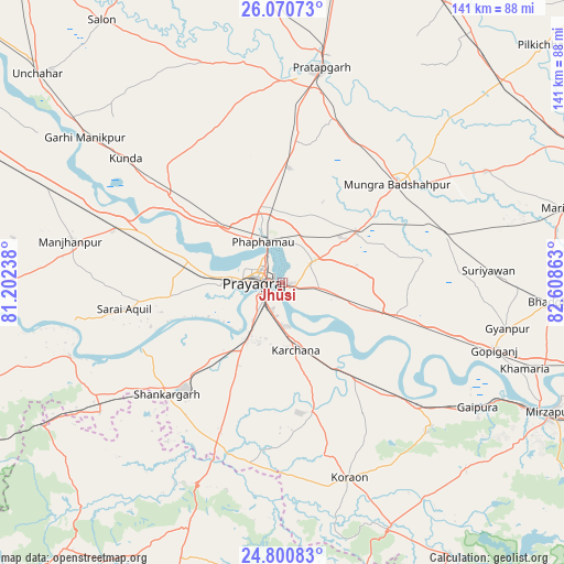
Jhūsi GPS coordinates[2]
25° 26' 14.82" North, 81° 54' 19.8" East
| Map corner | latitude | longitude |
|---|---|---|
| Upper-left | 26.07073°, | 81.20238° |
| Center: | 25.43745°, | 81.9055° |
| Lower-right: | 24.80083°, | 82.60863° |
| Map W x H: | 141.2×141.2 km | = 87.7×87.7mi |
| max Lat: | 34.9274° ⇑33.7% North |
| Jhūsi: | 25.43745° |
| min Lat: | ⇓66.3% South 8.09008° |
| min Long | Jhūsi | max Long |
| 68.82655° | 81.9055° | 96.81° |
| W 76.2%⇐ | ⇒23.8% E |
Elevation
Elevation of Jhūsi is 95 m = 312 ft, and this is 200.6 m = 658 ft below average elevation for this country.
| Max E: |
3681 m = 12077 ft | 69.4% |
| Avg. | 295.6 m = 970 ft | |
| Jhūsi | 95 m = 312 ft | |
Min E: |
1 m = 3 ft | 30.6% |
See also: India elevation on elevation.city.
Geographical zone
Jhūsi is located in North temperate zone (between Tropic of Cancer and the Arctic Circle). Distance of this Northern Tropic circle is 222.5 km =138.3 mi to South.| Distance of | km | miles | from Jhūsi |
|---|---|---|---|
| North Pole | 7178.7 | 4460.6 | to North |
| Arctic Circle | 4572.8 | 2841.4 | to North |
| Tropic Cancer | 222.5 | 138.3 | to South |
| Equator | 2828.4 | 1757.5 | to South |


Nearby cities:
15 places around Jhūsi: (largest is in red/bold)
• Allahābād
6.3 km =3.9 mi,  277°
277°
• Bela
54.5 km =33.9 mi,  9°
9°
• Bharwāri
43.7 km =27.2 mi,  288°
288°
• Chail
27.5 km =17.1 mi,  267°
267°
• Handiā
29.4 km =18.3 mi,  106°
106°
• Karārī
48.1 km =29.9 mi, 271°
• Kunda
50.1 km =31.1 mi,  308°
308°
• Manjhanpur
54.2 km =33.7 mi, 281°
• Mau Aimma
28.7 km =17.8 mi,  3°
3°
• Phulpur
22.2 km =13.8 mi,  56°
56°
• Pratāpgarh
51 km =31.7 mi, 4°
• Sarāi Ākil
40.2 km =25 mi,  260°
260°
• Shankargarh
40.5 km =25.2 mi,  225°
225°
• Sirsā
26.9 km =16.7 mi,  135°
135°
• Suriānwān
51.7 km =32.1 mi,  86°
86°
Sources, notices
• [Note1] Compared only with cities in India existing in our database
• [Src1] Map data: © OpenStreetMap contributors (CC-BY-SA)
• [Src2] Other city data from geonames.org with taken over terms of usage.
• [Src3] Geographical zone / Annual Mean Temperature by Robert A. Rohde @ Wikipedia
