Chail geodata
Chail (Uttar Pradesh) is a populated place; located in India in Asia/Kolkata (GMT+5.5) time zone. With population of 8,407 people, there are 3089 cities with bigger population in this country. Compared to other cities in India, 66.2% of cities are located further ↓South; 75.2% of cities are located further ←West and 67.4% of cities have higher elevation than Chail. Note1


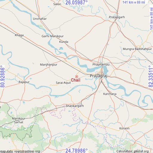
Chail GPS coordinates[2]
25° 25' 35.544" North, 81° 37' 55.128" East
| Map corner | latitude | longitude |
|---|---|---|
| Upper-left | 26.05987°, | 80.92886° |
| Center: | 25.42654°, | 81.63198° |
| Lower-right: | 24.78986°, | 82.33511° |
| Map W x H: | 141.2×141.2 km | = 87.7×87.7mi |
| max Lat: | 34.9274° ⇑33.8% North |
| Chail: | 25.42654° |
| min Lat: | ⇓66.2% South 8.09008° |
| min Long | Chail | max Long |
| 68.82655° | 81.63198° | 96.81° |
| W 75.2%⇐ | ⇒24.8% E |
Elevation
Elevation of Chail is 105 m = 344 ft, and this is 190.6 m = 625 ft below average elevation for this country.
| Max E: |
3681 m = 12077 ft | 67.4% |
| Avg. | 295.6 m = 970 ft | |
| Chail | 105 m = 344 ft | |
Min E: |
1 m = 3 ft | 32.6% |
See also: India elevation on elevation.city.
Geographical zone
Chail is located in North temperate zone (between Tropic of Cancer and the Arctic Circle). Distance of this Northern Tropic circle is 221.2 km =137.4 mi to South.| Distance of | km | miles | from Chail |
|---|---|---|---|
| North Pole | 7179.9 | 4461.4 | to North |
| Arctic Circle | 4574 | 2842.2 | to North |
| Tropic Cancer | 221.2 | 137.4 | to South |
| Equator | 2827.2 | 1756.7 | to South |


Nearby cities:
15 places around Chail: (largest is in red/bold)
• Allahābād
21.3 km =13.2 mi,  84°
84°
• Bharwāri
20.5 km =12.7 mi,  316°
316°
• Jhūsi
27.5 km =17.1 mi,  87°
87°
• Karārī
20.8 km =12.9 mi,  277°
277°
• Kunda
34.4 km =21.4 mi,  339°
339°
• Manjhanpur
28.2 km =17.5 mi,  294°
294°
• Mau Aimma
41.8 km =26 mi,  44°
44°
• Phulpur
47.9 km =29.8 mi,  73°
73°
• Rājāpur
48.5 km =30.1 mi,  264°
264°
• Sarāi Ākil
13.3 km =8.3 mi,  246°
246°
• Shankargarh
27.2 km =16.9 mi,  183°
183°
• Sirsā
49.6 km =30.8 mi,  111°
111°
• Sirāthu
39.6 km =24.6 mi,  307°
307°
• Sohāgi
49.9 km =31 mi,  172°
172°
• Teonthar
49.4 km =30.7 mi, 178°
Sources, notices
• [Note1] Compared only with cities in India existing in our database
• [Src1] Map data: © OpenStreetMap contributors (CC-BY-SA)
• [Src2] Other city data from geonames.org with taken over terms of usage.
• [Src3] Geographical zone / Annual Mean Temperature by Robert A. Rohde @ Wikipedia
