Susner geodata
Susner (Madhya Pradesh) is a populated place; located in India in Asia/Kolkata (GMT+5.5) time zone. With population of 14,601 people, there are 2502 cities with bigger population in this country. Compared to other cities in India, 57.9% of cities are located further ↓South; 72.7% of cities are located further →East and 77.1% of cities have lower elevation than Susner. Note1


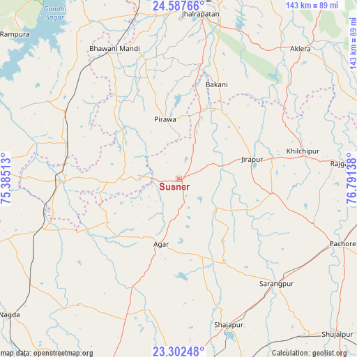
Susner GPS coordinates[2]
23° 56' 48.012" North, 76° 5' 17.7" East
| Map corner | latitude | longitude |
|---|---|---|
| Upper-left | 24.58766°, | 75.38513° |
| Center: | 23.94667°, | 76.08825° |
| Lower-right: | 23.30248°, | 76.79138° |
| Map W x H: | 142.9×142.9 km | = 88.8×88.8mi |
| max Lat: | 34.9274° ⇑42.1% North |
| Susner: | 23.94667° |
| min Lat: | ⇓57.9% South 8.09008° |
| min Long | Susner | max Long |
| 68.82655° | 76.08825° | 96.81° |
| W 27.3%⇐ | ⇒72.7% E |
Elevation
Elevation of Susner is 417 m = 1368 ft, and this is 121.4 m = 398 ft above average elevation for this country.
| Max E: |
3681 m = 12077 ft | 22.9% |
| Susner | 417 m 1368 ft | |
| Avg. | 295.6 m = 970 ft | |
Min E: |
1 m = 3 ft | 77.1% |
See also: India elevation on elevation.city.
Geographical zone
Susner is located in North temperate zone (between Tropic of Cancer and the Arctic Circle). Distance of this Northern Tropic circle is 56.7 km =35.2 mi to South.| Distance of | km | miles | from Susner |
|---|---|---|---|
| North Pole | 7344.4 | 4563.6 | to North |
| Arctic Circle | 4738.6 | 2944.4 | to North |
| Tropic Cancer | 56.7 | 35.2 | to South |
| Equator | 2662.6 | 1654.5 | to South |


Nearby cities:
15 places around Susner: (largest is in red/bold)
• Agar
27.1 km =16.8 mi,  195°
195°
• Alot
57.8 km =35.9 mi,  249°
249°
• Bakāni
40.7 km =25.3 mi,  21°
21°
• Bhawāniganj
58.1 km =36.1 mi,  333°
333°
• Jhālrapātan
66.7 km =41.4 mi,  7°
7°
• Khilchipur
50.8 km =31.6 mi,  78°
78°
• Khujner
56.7 km =35.2 mi,  108°
108°
• Māchalpur
30.7 km =19.1 mi,  49°
49°
• Pirāwa
24 km =14.9 mi,  345°
345°
• Rājgarh
65.8 km =40.9 mi, 84°
• Shājāpur
61 km =37.9 mi,  161°
161°
• Shāmgarh
52.9 km =32.9 mi,  300°
300°
• Sunel
49 km =30.4 mi,  344°
344°
• Sārangpur
57.6 km =35.8 mi,  137°
137°
• Tarāna
68.3 km =42.4 mi,  183°
183°
Sources, notices
• [Note1] Compared only with cities in India existing in our database
• [Src1] Map data: © OpenStreetMap contributors (CC-BY-SA)
• [Src2] Other city data from geonames.org with taken over terms of usage.
• [Src3] Geographical zone / Annual Mean Temperature by Robert A. Rohde @ Wikipedia
