Pirāwa geodata
Pirāwa (Rajasthan) is a populated place; located in India in Asia/Kolkata (GMT+5.5) time zone. With population of 11,790 people, there are 2758 cities with bigger population in this country. Compared to other cities in India, 58.8% of cities are located further ↓South; 73.4% of cities are located further →East and 73.9% of cities have lower elevation than Pirāwa. Note1


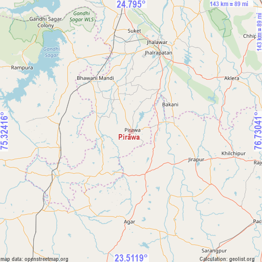
Pirāwa GPS coordinates[2]
24° 9' 18.216" North, 76° 1' 38.208" East
| Map corner | latitude | longitude |
|---|---|---|
| Upper-left | 24.795°, | 75.32416° |
| Center: | 24.15506°, | 76.02728° |
| Lower-right: | 23.5119°, | 76.73041° |
| Map W x H: | 142.7×142.7 km | = 88.7×88.7mi |
| max Lat: | 34.9274° ⇑41.2% North |
| Pirāwa: | 24.15506° |
| min Lat: | ⇓58.8% South 8.09008° |
| min Long | Pirāwa | max Long |
| 68.82655° | 76.02728° | 96.81° |
| W 26.6%⇐ | ⇒73.4% E |
Elevation
Elevation of Pirāwa is 372 m = 1220 ft, and this is 76.4 m = 251 ft above average elevation for this country.
| Max E: |
3681 m = 12077 ft | 26.1% |
| Pirāwa | 372 m 1220 ft | |
| Avg. | 295.6 m = 970 ft | |
Min E: |
1 m = 3 ft | 73.9% |
See also: India elevation on elevation.city.
Geographical zone
Pirāwa is located in North temperate zone (between Tropic of Cancer and the Arctic Circle). Distance of this Northern Tropic circle is 79.9 km =49.6 mi to South.| Distance of | km | miles | from Pirāwa |
|---|---|---|---|
| North Pole | 7321.3 | 4549.2 | to North |
| Arctic Circle | 4715.4 | 2930 | to North |
| Tropic Cancer | 79.9 | 49.6 | to South |
| Equator | 2685.8 | 1668.9 | to South |


Nearby cities:
15 places around Pirāwa: (largest is in red/bold)
• Agar
49.3 km =30.6 mi,  181°
181°
• Aklera
61.8 km =38.4 mi,  62°
62°
• Bakāni
25.8 km =16 mi, 55°
• Bhawāniganj
34.9 km =21.7 mi,  326°
326°
• Bhānpura
48.9 km =30.4 mi,  324°
324°
• Jhālrapātan
45.5 km =28.3 mi,  18°
18°
• Jhālāwār
51 km =31.7 mi, 15°
• Khilchipur
57.4 km =35.7 mi,  102°
102°
• Māchalpur
29.5 km =18.3 mi, 95°
• Rāmganj Mandi
55.3 km =34.4 mi,  351°
351°
• Shāmgarh
39.6 km =24.6 mi,  275°
275°
• Suket
54.6 km =33.9 mi,  1°
1°
• Sunel
25 km =15.5 mi,  343°
343°
• Susner
24 km =14.9 mi,  165°
165°
• Udpura
64.5 km =40.1 mi,  355°
355°
Sources, notices
• [Note1] Compared only with cities in India existing in our database
• [Src1] Map data: © OpenStreetMap contributors (CC-BY-SA)
• [Src2] Other city data from geonames.org with taken over terms of usage.
• [Src3] Geographical zone / Annual Mean Temperature by Robert A. Rohde @ Wikipedia
