Bakāni geodata
Bakāni (Rajasthan) is a populated place; located in India in Asia/Kolkata (GMT+5.5) time zone. With population of 8,621 people, there are 3068 cities with bigger population in this country. Compared to other cities in India, 59.5% of cities are located further ↓South; 71.2% of cities are located further →East and 72.1% of cities have lower elevation than Bakāni. Note1


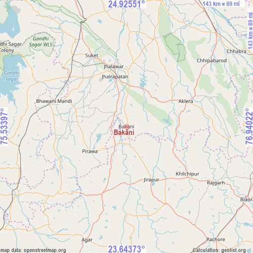
Bakāni GPS coordinates[2]
24° 17' 10.464" North, 76° 14' 13.524" East
| Map corner | latitude | longitude |
|---|---|---|
| Upper-left | 24.92551°, | 75.53397° |
| Center: | 24.28624°, | 76.23709° |
| Lower-right: | 23.64373°, | 76.94022° |
| Map W x H: | 142.5×142.5 km | = 88.5×88.5mi |
| max Lat: | 34.9274° ⇑40.5% North |
| Bakāni: | 24.28624° |
| min Lat: | ⇓59.5% South 8.09008° |
| min Long | Bakāni | max Long |
| 68.82655° | 76.23709° | 96.81° |
| W 28.8%⇐ | ⇒71.2% E |
Elevation
Elevation of Bakāni is 350 m = 1148 ft, and this is 54.4 m = 178 ft above average elevation for this country.
| Max E: |
3681 m = 12077 ft | 27.9% |
| Bakāni | 350 m 1148 ft | |
| Avg. | 295.6 m = 970 ft | |
Min E: |
1 m = 3 ft | 72.1% |
See also: India elevation on elevation.city.
Geographical zone
Bakāni is located in North temperate zone (between Tropic of Cancer and the Arctic Circle). Distance of this Northern Tropic circle is 94.5 km =58.7 mi to South.| Distance of | km | miles | from Bakāni |
|---|---|---|---|
| North Pole | 7306.7 | 4540.2 | to North |
| Arctic Circle | 4700.8 | 2920.9 | to North |
| Tropic Cancer | 94.5 | 58.7 | to South |
| Equator | 2700.4 | 1678 | to South |


Nearby cities:
15 places around Bakāni: (largest is in red/bold)
• Aklera
36.3 km =22.6 mi,  67°
67°
• Bhawāniganj
43.2 km =26.8 mi,  289°
289°
• Bhānpura
55.7 km =34.6 mi,  296°
296°
• Jhālrapātan
29.2 km =18.1 mi,  347°
347°
• Jhālāwār
35.2 km =21.9 mi, 348°
• Khilchipur
44.1 km =27.4 mi,  128°
128°
• Khānpur
52.1 km =32.4 mi,  17°
17°
• Manohar Thāna
57.5 km =35.7 mi,  95°
95°
• Māchalpur
19.4 km =12.1 mi,  155°
155°
• Pirāwa
25.8 km =16 mi,  235°
235°
• Rāmganj Mandi
49.9 km =31 mi,  323°
323°
• Suket
44.6 km =27.7 mi,  333°
333°
• Sunel
29.9 km =18.6 mi, 288°
• Susner
40.7 km =25.3 mi,  201°
201°
• Udpura
56.4 km =35 mi, 331°
Sources, notices
• [Note1] Compared only with cities in India existing in our database
• [Src1] Map data: © OpenStreetMap contributors (CC-BY-SA)
• [Src2] Other city data from geonames.org with taken over terms of usage.
• [Src3] Geographical zone / Annual Mean Temperature by Robert A. Rohde @ Wikipedia
