Sarāhan geodata
Sarāhan (Himachal Pradesh) is a populated place; located in India in Asia/Kolkata (GMT+5.5) time zone. With population of 1,495 people, there are 3449 cities with bigger population in this country. Compared to other cities in India, 96.9% of cities are located further ↓South; 53.7% of cities are located further →East and 99.6% of cities have lower elevation than Sarāhan. Note1


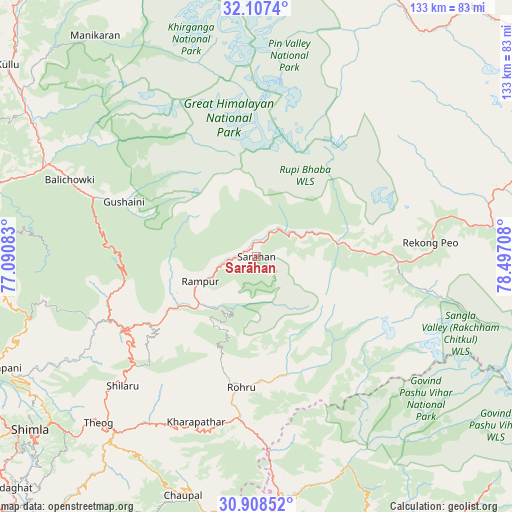
Sarāhan GPS coordinates[2]
31° 30' 35.568" North, 77° 47' 38.22" East
| Map corner | latitude | longitude |
|---|---|---|
| Upper-left | 32.1074°, | 77.09083° |
| Center: | 31.50988°, | 77.79395° |
| Lower-right: | 30.90852°, | 78.49708° |
| Map W x H: | 133.3×133.3 km | = 82.8×82.8mi |
| max Lat: | 34.9274° ⇑3.1% North |
| Sarāhan: | 31.50988° |
| min Lat: | ⇓96.9% South 8.09008° |
| min Long | Sarāhan | max Long |
| 68.82655° | 77.79395° | 96.81° |
| W 46.3%⇐ | ⇒53.7% E |
Elevation
Elevation of Sarāhan is 2161 m = 7090 ft, and this is 1865.4 m = 6120 ft above average elevation for this country.
| Max E: |
3681 m = 12077 ft | 0.40000000000001% |
| Sarāhan | 2161 m 7090 ft | |
| Avg. | 295.6 m = 970 ft | |
Min E: |
1 m = 3 ft | 99.6% |
See also: India elevation on elevation.city.
Geographical zone
Sarāhan is located in North temperate zone (between Tropic of Cancer and the Arctic Circle). Distance of this Northern Tropic circle is 897.7 km =557.8 mi to South.| Distance of | km | miles | from Sarāhan |
|---|---|---|---|
| North Pole | 6503.5 | 4041.1 | to North |
| Arctic Circle | 3897.6 | 2421.9 | to North |
| Tropic Cancer | 897.7 | 557.8 | to South |
| Equator | 3503.6 | 2177 | to South |


Nearby cities:
15 places around Sarāhan: (largest is in red/bold)
• Banjār
45.3 km =28.1 mi,  288°
288°
• Chaupāl
65.6 km =40.8 mi,  197°
197°
• Jubbal
46.6 km =29 mi, 196°
• Jutogh
78.8 km =49 mi,  234°
234°
• Kotkhai
49.9 km =31 mi,  208°
208°
• Kulu
81.8 km =50.8 mi,  307°
307°
• Mandi
84.6 km =52.6 mi, 285°
• Nārkanda
42.3 km =26.3 mi, 228°
• Pāndoh
72.3 km =44.9 mi,  284°
284°
• Rohru
34.4 km =21.4 mi,  186°
186°
• Rāmpur
16.9 km =10.5 mi,  246°
246°
• Seoni
70.3 km =43.7 mi,  244°
244°
• Shimla
74.7 km =46.4 mi, 232°
• Sundarnagar
84.3 km =52.4 mi,  271°
271°
• Theog
59.8 km =37.2 mi,  223°
223°
Sources, notices
• [Note1] Compared only with cities in India existing in our database
• [Src1] Map data: © OpenStreetMap contributors (CC-BY-SA)
• [Src2] Other city data from geonames.org with taken over terms of usage.
• [Src3] Geographical zone / Annual Mean Temperature by Robert A. Rohde @ Wikipedia
