Rohru geodata
Rohru (Himachal Pradesh) is a populated place; located in India in Asia/Kolkata (GMT+5.5) time zone. With population of 8,160 people, there are 3113 cities with bigger population in this country. Compared to other cities in India, 96.3% of cities are located further ↓South; 54.3% of cities are located further →East and 97.9% of cities have lower elevation than Rohru. Note1


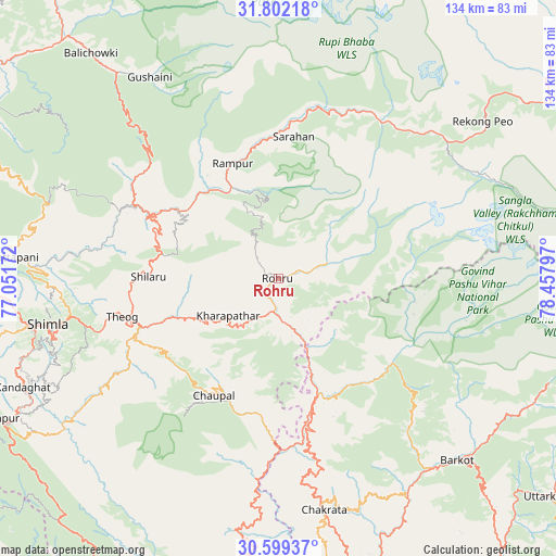
Rohru GPS coordinates[2]
31° 12' 9.684" North, 77° 45' 17.424" East
| Map corner | latitude | longitude |
|---|---|---|
| Upper-left | 31.80218°, | 77.05172° |
| Center: | 31.20269°, | 77.75484° |
| Lower-right: | 30.59937°, | 78.45797° |
| Map W x H: | 133.7×133.7 km | = 83.1×83.1mi |
| max Lat: | 34.9274° ⇑3.7% North |
| Rohru: | 31.20269° |
| min Lat: | ⇓96.3% South 8.09008° |
| min Long | Rohru | max Long |
| 68.82655° | 77.75484° | 96.81° |
| W 45.7%⇐ | ⇒54.3% E |
Elevation
Elevation of Rohru is 1537 m = 5043 ft, and this is 1241.4 m = 4073 ft above average elevation for this country.
| Max E: |
3681 m = 12077 ft | 2.1% |
| Rohru | 1537 m 5043 ft | |
| Avg. | 295.6 m = 970 ft | |
Min E: |
1 m = 3 ft | 97.9% |
See also: India elevation on elevation.city.
Geographical zone
Rohru is located in North temperate zone (between Tropic of Cancer and the Arctic Circle). Distance of this Northern Tropic circle is 863.5 km =536.6 mi to South.| Distance of | km | miles | from Rohru |
|---|---|---|---|
| North Pole | 6537.6 | 4062.3 | to North |
| Arctic Circle | 3931.8 | 2443.1 | to North |
| Tropic Cancer | 863.5 | 536.6 | to South |
| Equator | 3469.4 | 2155.8 | to South |


Nearby cities:
15 places around Rohru: (largest is in red/bold)
• Banjār
62.4 km =38.8 mi,  320°
320°
• Barkot
61.4 km =38.2 mi,  135°
135°
• Chakrāta
56.4 km =35 mi,  169°
169°
• Chaupāl
32.6 km =20.3 mi,  209°
209°
• Jubbal
14.3 km =8.9 mi,  223°
223°
• Jutogh
61.8 km =38.4 mi,  259°
259°
• Kotkhai
22.6 km =14 mi,  245°
245°
• Nārkanda
28.6 km =17.8 mi,  282°
282°
• Rājgarh
58.3 km =36.2 mi,  227°
227°
• Rāmpur
29.9 km =18.6 mi,  336°
336°
• Sarāhan
34.4 km =21.4 mi,  6°
6°
• Seoni
60.2 km =37.4 mi,  274°
274°
• Shimla
57 km =35.4 mi, 258°
• Solan
69.7 km =43.3 mi,  242°
242°
• Theog
38.8 km =24.1 mi, 256°
Sources, notices
• [Note1] Compared only with cities in India existing in our database
• [Src1] Map data: © OpenStreetMap contributors (CC-BY-SA)
• [Src2] Other city data from geonames.org with taken over terms of usage.
• [Src3] Geographical zone / Annual Mean Temperature by Robert A. Rohde @ Wikipedia
