Theog geodata
Theog (Himachal Pradesh) is a populated place; located in India in Asia/Kolkata (GMT+5.5) time zone. With population of 4,191 people, there are 3371 cities with bigger population in this country. Compared to other cities in India, 96.1% of cities are located further ↓South; 58.7% of cities are located further →East and 99.6% of cities have lower elevation than Theog. Note1


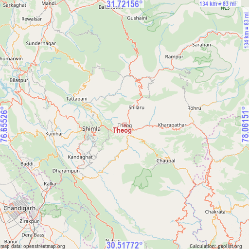
Theog GPS coordinates[2]
31° 7' 17.58" North, 77° 21' 30.168" East
| Map corner | latitude | longitude |
|---|---|---|
| Upper-left | 31.72156°, | 76.65526° |
| Center: | 31.12155°, | 77.35838° |
| Lower-right: | 30.51772°, | 78.06151° |
| Map W x H: | 133.9×133.9 km | = 83.2×83.2mi |
| max Lat: | 34.9274° ⇑3.9% North |
| Theog: | 31.12155° |
| min Lat: | ⇓96.1% South 8.09008° |
| min Long | Theog | max Long |
| 68.82655° | 77.35838° | 96.81° |
| W 41.3%⇐ | ⇒58.7% E |
Elevation
Elevation of Theog is 2239 m = 7346 ft, and this is 1943.4 m = 6376 ft above average elevation for this country.
| Max E: |
3681 m = 12077 ft | 0.40000000000001% |
| Theog | 2239 m 7346 ft | |
| Avg. | 295.6 m = 970 ft | |
Min E: |
1 m = 3 ft | 99.6% |
See also: India elevation on elevation.city.
Geographical zone
Theog is located in North temperate zone (between Tropic of Cancer and the Arctic Circle). Distance of this Northern Tropic circle is 854.5 km =531 mi to South.| Distance of | km | miles | from Theog |
|---|---|---|---|
| North Pole | 6546.7 | 4067.9 | to North |
| Arctic Circle | 3940.8 | 2448.7 | to North |
| Tropic Cancer | 854.5 | 531 | to South |
| Equator | 3460.4 | 2150.2 | to South |


Nearby cities:
15 places around Theog: (largest is in red/bold)
• Arki
37.4 km =23.2 mi,  275°
275°
• Chaupāl
29.3 km =18.2 mi,  131°
131°
• Dagshai
39.3 km =24.4 mi,  227°
227°
• Jubbal
27.9 km =17.3 mi,  92°
92°
• Jutogh
23.1 km =14.4 mi,  264°
264°
• Kasauli
44.9 km =27.9 mi,  236°
236°
• Kotkhai
17.2 km =10.7 mi, 91°
• Nārkanda
18 km =11.2 mi,  32°
32°
• Rohru
38.8 km =24.1 mi,  76°
76°
• Rājgarh
30.5 km =19 mi,  190°
190°
• Rāmpur
44.7 km =27.8 mi,  35°
35°
• Sabāthu
38.6 km =24 mi,  245°
245°
• Seoni
26 km =16.2 mi,  300°
300°
• Shimla
18.4 km =11.4 mi, 264°
• Solan
33.5 km =20.8 mi, 225°
Sources, notices
• [Note1] Compared only with cities in India existing in our database
• [Src1] Map data: © OpenStreetMap contributors (CC-BY-SA)
• [Src2] Other city data from geonames.org with taken over terms of usage.
• [Src3] Geographical zone / Annual Mean Temperature by Robert A. Rohde @ Wikipedia
