Jubbal geodata
Jubbal (Himachal Pradesh) is a populated place; located in India in Asia/Kolkata (GMT+5.5) time zone. With population of 1,327 people, there are 3454 cities with bigger population in this country. Compared to other cities in India, 96% of cities are located further ↓South; 55.5% of cities are located further →East and 99.4% of cities have lower elevation than Jubbal. Note1


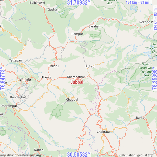
Jubbal GPS coordinates[2]
31° 6' 33.228" North, 77° 39' 3.06" East
| Map corner | latitude | longitude |
|---|---|---|
| Upper-left | 31.70932°, | 76.94773° |
| Center: | 31.10923°, | 77.65085° |
| Lower-right: | 30.50532°, | 78.35398° |
| Map W x H: | 133.9×133.9 km | = 83.2×83.2mi |
| max Lat: | 34.9274° ⇑4% North |
| Jubbal: | 31.10923° |
| min Lat: | ⇓96% South 8.09008° |
| min Long | Jubbal | max Long |
| 68.82655° | 77.65085° | 96.81° |
| W 44.5%⇐ | ⇒55.5% E |
Elevation
Elevation of Jubbal is 2100 m = 6890 ft, and this is 1804.4 m = 5920 ft above average elevation for this country.
| Max E: |
3681 m = 12077 ft | 0.59999999999999% |
| Jubbal | 2100 m 6890 ft | |
| Avg. | 295.6 m = 970 ft | |
Min E: |
1 m = 3 ft | 99.4% |
See also: India elevation on elevation.city.
Geographical zone
Jubbal is located in North temperate zone (between Tropic of Cancer and the Arctic Circle). Distance of this Northern Tropic circle is 853.1 km =530.1 mi to South.| Distance of | km | miles | from Jubbal |
|---|---|---|---|
| North Pole | 6548 | 4068.7 | to North |
| Arctic Circle | 3942.2 | 2449.6 | to North |
| Tropic Cancer | 853.1 | 530.1 | to South |
| Equator | 3459 | 2149.3 | to South |


Nearby cities:
15 places around Jubbal: (largest is in red/bold)
• Barkot
62.6 km =38.9 mi,  122°
122°
• Chakrāta
49.5 km =30.8 mi,  155°
155°
• Chaupāl
19.1 km =11.9 mi,  198°
198°
• Dagshai
62.3 km =38.7 mi,  246°
246°
• Jutogh
50.9 km =31.6 mi,  268°
268°
• Kotkhai
10.7 km =6.6 mi, 274°
• Nārkanda
24.4 km =15.2 mi,  312°
312°
• Rohru
14.3 km =8.9 mi,  43°
43°
• Rājgarh
44 km =27.3 mi,  229°
229°
• Rāmpur
37.9 km =23.5 mi,  357°
357°
• Sarāhan
46.6 km =29 mi,  16°
16°
• Seoni
52.3 km =32.5 mi,  286°
286°
• Shimla
46.1 km =28.6 mi, 269°
• Solan
56.3 km =35 mi, 246°
• Theog
27.9 km =17.3 mi, 272°
Sources, notices
• [Note1] Compared only with cities in India existing in our database
• [Src1] Map data: © OpenStreetMap contributors (CC-BY-SA)
• [Src2] Other city data from geonames.org with taken over terms of usage.
• [Src3] Geographical zone / Annual Mean Temperature by Robert A. Rohde @ Wikipedia
