Babrāla geodata
Babrāla (Uttar Pradesh) is a populated place; located in India in Asia/Kolkata (GMT+5.5) time zone. With population of 16,670 people, there are 2317 cities with bigger population in this country. Compared to other cities in India, 85.8% of cities are located further ↓South; 53.1% of cities are located further ←West and 53% of cities have higher elevation than Babrāla. Note1


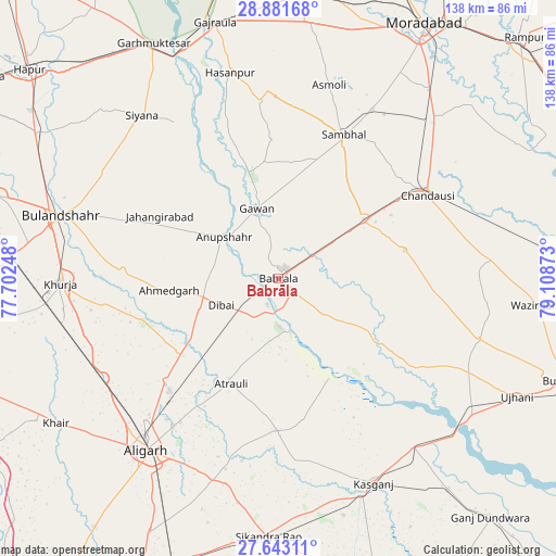
Babrāla GPS coordinates[2]
28° 15' 51.084" North, 78° 24' 20.16" East
| Map corner | latitude | longitude |
|---|---|---|
| Upper-left | 28.88168°, | 77.70248° |
| Center: | 28.26419°, | 78.4056° |
| Lower-right: | 27.64311°, | 79.10873° |
| Map W x H: | 137.7×137.7 km | = 85.6×85.6mi |
| max Lat: | 34.9274° ⇑14.2% North |
| Babrāla: | 28.26419° |
| min Lat: | ⇓85.8% South 8.09008° |
| min Long | Babrāla | max Long |
| 68.82655° | 78.4056° | 96.81° |
| W 53.1%⇐ | ⇒46.9% E |
Elevation
Elevation of Babrāla is 184 m = 604 ft, and this is 111.6 m = 366 ft below average elevation for this country.
| Max E: |
3681 m = 12077 ft | 53% |
| Avg. | 295.6 m = 970 ft | |
| Babrāla | 184 m = 604 ft | |
Min E: |
1 m = 3 ft | 47% |
See also: India elevation on elevation.city.
Geographical zone
Babrāla is located in North temperate zone (between Tropic of Cancer and the Arctic Circle). Distance of this Northern Tropic circle is 536.8 km =333.6 mi to South.| Distance of | km | miles | from Babrāla |
|---|---|---|---|
| North Pole | 6864.4 | 4265.3 | to North |
| Arctic Circle | 4258.5 | 2646.1 | to North |
| Tropic Cancer | 536.8 | 333.6 | to South |
| Equator | 3142.7 | 1952.8 | to South |


Nearby cities:
15 places around Babrāla: (largest is in red/bold)
• Anūpshahr
16.9 km =10.5 mi,  307°
307°
• Atraulī
28.6 km =17.8 mi,  204°
204°
• Bahjoi
26.1 km =16.2 mi,  56°
56°
• Chharra
37.8 km =23.5 mi,  180°
180°
• Dibai
15.4 km =9.6 mi,  246°
246°
• Gawān
18.1 km =11.2 mi,  343°
343°
• Gunnaur
4.3 km =2.7 mi,  128°
128°
• Islāmnagar
32.1 km =19.9 mi,  77°
77°
• Jahāngīrābād
33.3 km =20.7 mi,  298°
298°
• Narauli
39 km =24.2 mi,  50°
50°
• Naraura
7.2 km =4.5 mi,  194°
194°
• Pahāsu
35 km =21.7 mi, 253°
• Sahaswān
40 km =24.9 mi,  122°
122°
• Sambhal
39.1 km =24.3 mi,  24°
24°
• Shikārpūr
38.4 km =23.9 mi,  272°
272°
Sources, notices
• [Note1] Compared only with cities in India existing in our database
• [Src1] Map data: © OpenStreetMap contributors (CC-BY-SA)
• [Src2] Other city data from geonames.org with taken over terms of usage.
• [Src3] Geographical zone / Annual Mean Temperature by Robert A. Rohde @ Wikipedia
