Anūpshahr geodata
Anūpshahr (Uttar Pradesh) is a populated place; located in India in Asia/Kolkata (GMT+5.5) time zone. With population of 25,306 people, there are 1680 cities with bigger population in this country. Compared to other cities in India, 86.2% of cities are located further ↓South; 52% of cities are located further ←West and 50.8% of cities have higher elevation than Anūpshahr. Note1


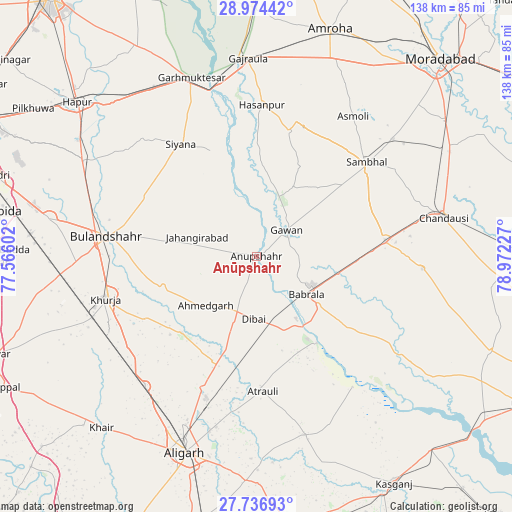
Anūpshahr GPS coordinates[2]
28° 21' 26.928" North, 78° 16' 8.904" East
| Map corner | latitude | longitude |
|---|---|---|
| Upper-left | 28.97442°, | 77.56602° |
| Center: | 28.35748°, | 78.26914° |
| Lower-right: | 27.73693°, | 78.97227° |
| Map W x H: | 137.6×137.6 km | = 85.5×85.5mi |
| max Lat: | 34.9274° ⇑13.8% North |
| Anūpshahr: | 28.35748° |
| min Lat: | ⇓86.2% South 8.09008° |
| min Long | Anūpshahr | max Long |
| 68.82655° | 78.26914° | 96.81° |
| W 52%⇐ | ⇒48% E |
Elevation
Elevation of Anūpshahr is 197 m = 646 ft, and this is 98.6 m = 323 ft below average elevation for this country.
| Max E: |
3681 m = 12077 ft | 50.8% |
| Avg. | 295.6 m = 970 ft | |
| Anūpshahr | 197 m = 646 ft | |
Min E: |
1 m = 3 ft | 49.2% |
See also: India elevation on elevation.city.
Geographical zone
Anūpshahr is located in North temperate zone (between Tropic of Cancer and the Arctic Circle). Distance of this Northern Tropic circle is 547.1 km =340 mi to South.| Distance of | km | miles | from Anūpshahr |
|---|---|---|---|
| North Pole | 6854 | 4258.9 | to North |
| Arctic Circle | 4248.1 | 2639.6 | to North |
| Tropic Cancer | 547.1 | 340 | to South |
| Equator | 3153.1 | 1959.2 | to South |


Nearby cities:
15 places around Anūpshahr: (largest is in red/bold)
• Atraulī
36.5 km =22.7 mi,  177°
177°
• Babrāla
16.9 km =10.5 mi,  127°
127°
• Bahjoi
35.2 km =21.9 mi,  83°
83°
• Bulandshahr
40.6 km =25.2 mi,  277°
277°
• Dibai
16.6 km =10.3 mi, 182°
• Gawān
10.6 km =6.6 mi,  49°
49°
• Gunnaur
21.2 km =13.2 mi, 128°
• Hasanpur
40.6 km =25.2 mi,  2°
2°
• Jahāngīrābād
16.8 km =10.4 mi,  288°
288°
• Khurja
42.1 km =26.2 mi,  254°
254°
• Khānpur
28 km =17.4 mi,  314°
314°
• Naraura
20.8 km =12.9 mi,  146°
146°
• Pahāsu
28.8 km =17.9 mi,  224°
224°
• Sambhal
38.8 km =24.1 mi, 49°
• Shikārpūr
26.4 km =16.4 mi, 251°
Sources, notices
• [Note1] Compared only with cities in India existing in our database
• [Src1] Map data: © OpenStreetMap contributors (CC-BY-SA)
• [Src2] Other city data from geonames.org with taken over terms of usage.
• [Src3] Geographical zone / Annual Mean Temperature by Robert A. Rohde @ Wikipedia
