Sirāthu geodata
Sirāthu (Uttar Pradesh) is a populated place; located in India in Asia/Kolkata (GMT+5.5) time zone. With population of 13,598 people, there are 2603 cities with bigger population in this country. Compared to other cities in India, 68% of cities are located further ↓South; 74% of cities are located further ←West and 66.2% of cities have higher elevation than Sirāthu. Note1


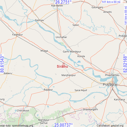
Sirāthu GPS coordinates[2]
25° 38' 34.512" North, 81° 19' 6.78" East
| Map corner | latitude | longitude |
|---|---|---|
| Upper-left | 26.2751°, | 80.61543° |
| Center: | 25.64292°, | 81.31855° |
| Lower-right: | 25.00737°, | 82.02168° |
| Map W x H: | 141×141 km | = 87.6×87.6mi |
| max Lat: | 34.9274° ⇑32% North |
| Sirāthu: | 25.64292° |
| min Lat: | ⇓68% South 8.09008° |
| min Long | Sirāthu | max Long |
| 68.82655° | 81.31855° | 96.81° |
| W 74%⇐ | ⇒26% E |
Elevation
Elevation of Sirāthu is 112 m = 367 ft, and this is 183.6 m = 602 ft below average elevation for this country.
| Max E: |
3681 m = 12077 ft | 66.2% |
| Avg. | 295.6 m = 970 ft | |
| Sirāthu | 112 m = 367 ft | |
Min E: |
1 m = 3 ft | 33.8% |
See also: India elevation on elevation.city.
Geographical zone
Sirāthu is located in North temperate zone (between Tropic of Cancer and the Arctic Circle). Distance of this Northern Tropic circle is 245.3 km =152.4 mi to South.| Distance of | km | miles | from Sirāthu |
|---|---|---|---|
| North Pole | 7155.8 | 4446.4 | to North |
| Arctic Circle | 4549.9 | 2827.2 | to North |
| Tropic Cancer | 245.3 | 152.4 | to South |
| Equator | 2851.2 | 1771.7 | to South |


Nearby cities:
15 places around Sirāthu: (largest is in red/bold)
• Allahābād
57.1 km =35.5 mi,  112°
112°
• Bharwāri
19.6 km =12.2 mi,  117°
117°
• Chail
39.6 km =24.6 mi,  127°
127°
• Dalmau
55.1 km =34.2 mi,  328°
328°
• Karārī
23.8 km =14.8 mi,  152°
152°
• Khāga
25.9 km =16.1 mi,  303°
303°
• Kishanpur
29.7 km =18.5 mi,  269°
269°
• Kunda
21.2 km =13.2 mi,  67°
67°
• Lālganj
50.3 km =31.3 mi,  50°
50°
• Manjhanpur
13.8 km =8.6 mi,  155°
155°
• Parshādepur
50.9 km =31.6 mi,  19°
19°
• Rājāpur
33 km =20.5 mi,  210°
210°
• Salon
45 km =28 mi, 17°
• Sarāi Ākil
35.1 km =21.8 mi, 146°
• Shankargarh
59.4 km =36.9 mi, 149°
Sources, notices
• [Note1] Compared only with cities in India existing in our database
• [Src1] Map data: © OpenStreetMap contributors (CC-BY-SA)
• [Src2] Other city data from geonames.org with taken over terms of usage.
• [Src3] Geographical zone / Annual Mean Temperature by Robert A. Rohde @ Wikipedia
