Bharwāri geodata
Bharwāri (Uttar Pradesh) is a populated place; located in India in Asia/Kolkata (GMT+5.5) time zone. With population of 16,411 people, there are 2334 cities with bigger population in this country. Compared to other cities in India, 67.3% of cities are located further ↓South; 74.5% of cities are located further ←West and 67.2% of cities have higher elevation than Bharwāri. Note1


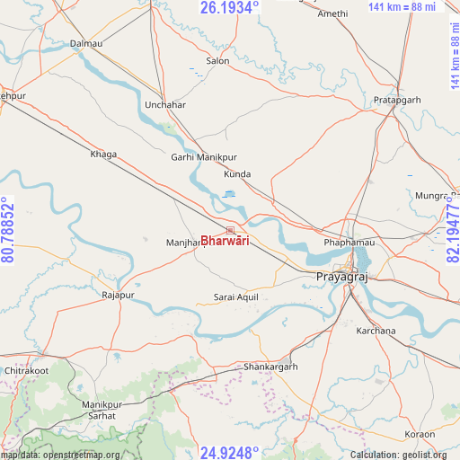
Bharwāri GPS coordinates[2]
25° 33' 38.808" North, 81° 29' 29.904" East
| Map corner | latitude | longitude |
|---|---|---|
| Upper-left | 26.1934°, | 80.78852° |
| Center: | 25.56078°, | 81.49164° |
| Lower-right: | 24.9248°, | 82.19477° |
| Map W x H: | 141.1×141.1 km | = 87.7×87.7mi |
| max Lat: | 34.9274° ⇑32.7% North |
| Bharwāri: | 25.56078° |
| min Lat: | ⇓67.3% South 8.09008° |
| min Long | Bharwāri | max Long |
| 68.82655° | 81.49164° | 96.81° |
| W 74.5%⇐ | ⇒25.5% E |
Elevation
Elevation of Bharwāri is 106 m = 348 ft, and this is 189.6 m = 622 ft below average elevation for this country.
| Max E: |
3681 m = 12077 ft | 67.2% |
| Avg. | 295.6 m = 970 ft | |
| Bharwāri | 106 m = 348 ft | |
Min E: |
1 m = 3 ft | 32.8% |
See also: India elevation on elevation.city.
Geographical zone
Bharwāri is located in North temperate zone (between Tropic of Cancer and the Arctic Circle). Distance of this Northern Tropic circle is 236.2 km =146.8 mi to South.| Distance of | km | miles | from Bharwāri |
|---|---|---|---|
| North Pole | 7165 | 4452.1 | to North |
| Arctic Circle | 4559.1 | 2832.9 | to North |
| Tropic Cancer | 236.2 | 146.8 | to South |
| Equator | 2842.1 | 1766 | to South |


Nearby cities:
15 places around Bharwāri: (largest is in red/bold)
• Allahābād
37.6 km =23.4 mi,  110°
110°
• Chail
20.5 km =12.7 mi,  136°
136°
• Jhūsi
43.7 km =27.2 mi, 108°
• Karārī
13.7 km =8.5 mi,  208°
208°
• Khāga
45.4 km =28.2 mi,  301°
301°
• Kishanpur
47.9 km =29.8 mi,  280°
280°
• Kunda
17.5 km =10.9 mi,  7°
7°
• Lālganj
46.5 km =28.9 mi,  27°
27°
• Manjhanpur
12.1 km =7.5 mi,  253°
253°
• Mau Aimma
45.8 km =28.5 mi,  70°
70°
• Rājāpur
39.2 km =24.4 mi,  240°
240°
• Salon
52.1 km =32.4 mi,  355°
355°
• Sarāi Ākil
20.3 km =12.6 mi,  174°
174°
• Shankargarh
44 km =27.3 mi,  163°
163°
• Sirāthu
19.6 km =12.2 mi, 297°
Sources, notices
• [Note1] Compared only with cities in India existing in our database
• [Src1] Map data: © OpenStreetMap contributors (CC-BY-SA)
• [Src2] Other city data from geonames.org with taken over terms of usage.
• [Src3] Geographical zone / Annual Mean Temperature by Robert A. Rohde @ Wikipedia
