Tehri geodata
Tehri (Uttarakhand) is a populated place; located in India in Asia/Kolkata (GMT+5.5) time zone. With population of 27,611 people, there are 1561 cities with bigger population in this country. Compared to other cities in India, 94% of cities are located further ↓South; 54% of cities are located further ←West and 91.1% of cities have lower elevation than Tehri. Note1


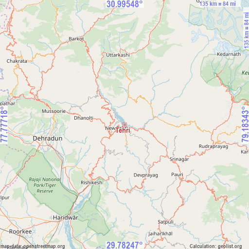
Tehri GPS coordinates[2]
30° 23' 27.096" North, 78° 28' 49.08" East
| Map corner | latitude | longitude |
|---|---|---|
| Upper-left | 30.99548°, | 77.77718° |
| Center: | 30.39086°, | 78.4803° |
| Lower-right: | 29.78247°, | 79.18343° |
| Map W x H: | 134.9×134.9 km | = 83.8×83.8mi |
| max Lat: | 34.9274° ⇑6% North |
| Tehri: | 30.39086° |
| min Lat: | ⇓94% South 8.09008° |
| min Long | Tehri | max Long |
| 68.82655° | 78.4803° | 96.81° |
| W 54%⇐ | ⇒46% E |
Elevation
Elevation of Tehri is 656 m = 2152 ft, and this is 360.4 m = 1182 ft above average elevation for this country.
| Max E: |
3681 m = 12077 ft | 8.9% |
| Tehri | 656 m 2152 ft | |
| Avg. | 295.6 m = 970 ft | |
Min E: |
1 m = 3 ft | 91.1% |
See also: India elevation on elevation.city.
Geographical zone
Tehri is located in North temperate zone (between Tropic of Cancer and the Arctic Circle). Distance of this Northern Tropic circle is 773.2 km =480.4 mi to South.| Distance of | km | miles | from Tehri |
|---|---|---|---|
| North Pole | 6627.9 | 4118.4 | to North |
| Arctic Circle | 4022 | 2499.2 | to North |
| Tropic Cancer | 773.2 | 480.4 | to South |
| Equator | 3379.1 | 2099.7 | to South |


Nearby cities:
15 places around Tehri: (largest is in red/bold)
• Barkot
53.4 km =33.2 mi,  330°
330°
• Birbhaddar
40.3 km =25 mi,  208°
208°
• Clement Town
47.4 km =29.5 mi,  252°
252°
• Dehra Dūn
43.5 km =27 mi,  260°
260°
• Devaprayāg
29.7 km =18.5 mi,  156°
156°
• Doiwāla
42.3 km =26.3 mi,  235°
235°
• Mussoorie
39.9 km =24.8 mi,  280°
280°
• Narendranagar
31.5 km =19.6 mi,  216°
216°
• Pauri
38.9 km =24.2 mi,  132°
132°
• Rishīkesh
36.3 km =22.6 mi, 209°
• Rudraprayāg
49.7 km =30.9 mi,  103°
103°
• Rāipur
38.5 km =23.9 mi, 256°
• Rāīwāla Bara
47.9 km =29.8 mi, 210°
• Srīnagar
34.6 km =21.5 mi,  122°
122°
• Uttarkāshi
37.9 km =23.5 mi,  354°
354°
Sources, notices
• [Note1] Compared only with cities in India existing in our database
• [Src1] Map data: © OpenStreetMap contributors (CC-BY-SA)
• [Src2] Other city data from geonames.org with taken over terms of usage.
• [Src3] Geographical zone / Annual Mean Temperature by Robert A. Rohde @ Wikipedia
