Pīlibhīt geodata
Pīlibhīt (Uttar Pradesh) is a populated place; located in India in Asia/Kolkata (GMT+5.5) time zone. With population of 131,008 people, there are 333 cities with bigger population in this country. Compared to other cities in India, 87.4% of cities are located further ↓South; 66.4% of cities are located further ←West and 52% of cities have higher elevation than Pīlibhīt. Note1


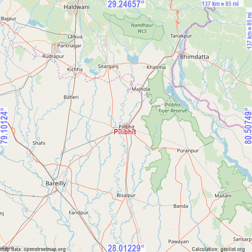
Pīlibhīt GPS coordinates[2]
28° 37' 52.464" North, 79° 48' 15.696" East
| Map corner | latitude | longitude |
|---|---|---|
| Upper-left | 29.24657°, | 79.10124° |
| Center: | 28.63124°, | 79.80436° |
| Lower-right: | 28.01229°, | 80.50749° |
| Map W x H: | 137.2×137.2 km | = 85.3×85.3mi |
| max Lat: | 34.9274° ⇑12.6% North |
| Pīlibhīt: | 28.63124° |
| min Lat: | ⇓87.4% South 8.09008° |
| min Long | Pīlibhīt | max Long |
| 68.82655° | 79.80436° | 96.81° |
| W 66.4%⇐ | ⇒33.6% E |
Elevation
Elevation of Pīlibhīt is 190 m = 623 ft, and this is 105.6 m = 346 ft below average elevation for this country.
| Max E: |
3681 m = 12077 ft | 52% |
| Avg. | 295.6 m = 970 ft | |
| Pīlibhīt | 190 m = 623 ft | |
Min E: |
1 m = 3 ft | 48% |
See also: Pīlibhīt elevation on elevation.city.
Geographical zone
Pīlibhīt is located in North temperate zone (between Tropic of Cancer and the Arctic Circle). Distance of this Northern Tropic circle is 577.6 km =358.9 mi to South.| Distance of | km | miles | from Pīlibhīt |
|---|---|---|---|
| North Pole | 6823.6 | 4240 | to North |
| Arctic Circle | 4217.7 | 2620.8 | to North |
| Tropic Cancer | 577.6 | 358.9 | to South |
| Equator | 3183.5 | 1978.1 | to South |


Nearby cities:
15 places around Pīlibhīt: (largest is in red/bold)
• Baheri
33.9 km =21.1 mi,  297°
297°
• Bareilly
46.8 km =29.1 mi,  231°
231°
• Barkhera Kalān
19.9 km =12.4 mi,  179°
179°
• Bilsanda
45.5 km =28.3 mi,  161°
161°
• Bīsalpur
37.7 km =23.4 mi, 179°
• Deoraniān
32 km =19.9 mi,  269°
269°
• Jahānābād
8.4 km =5.2 mi, 269°
• Khatīma
36.1 km =22.4 mi,  26°
26°
• Kichha
41.7 km =25.9 mi,  318°
318°
• Kālīnagar
27.1 km =16.8 mi,  92°
92°
• Nawābganj
19.4 km =12.1 mi,  238°
238°
• Pūranpur
36.1 km =22.4 mi,  111°
111°
• Richha
28.4 km =17.6 mi,  284°
284°
• Shergarh
42.6 km =26.5 mi, 272°
• Sitārganj
34.5 km =21.4 mi,  343°
343°
Sources, notices
• [Note1] Compared only with cities in India existing in our database
• [Src1] Map data: © OpenStreetMap contributors (CC-BY-SA)
• [Src2] Other city data from geonames.org with taken over terms of usage.
• [Src3] Geographical zone / Annual Mean Temperature by Robert A. Rohde @ Wikipedia
