Jahānābād geodata
Jahānābād (Uttar Pradesh) is a populated place; located in India in Asia/Kolkata (GMT+5.5) time zone. With population of 13,617 people, there are 2602 cities with bigger population in this country. Compared to other cities in India, 87.4% of cities are located further ↓South; 65.8% of cities are located further ←West and 52.7% of cities have higher elevation than Jahānābād. Note1


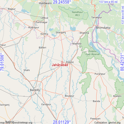
Jahānābād GPS coordinates[2]
28° 37' 48.9" North, 79° 43' 5.448" East
| Map corner | latitude | longitude |
|---|---|---|
| Upper-left | 29.24558°, | 79.01506° |
| Center: | 28.63025°, | 79.71818° |
| Lower-right: | 28.01129°, | 80.42131° |
| Map W x H: | 137.2×137.2 km | = 85.3×85.3mi |
| max Lat: | 34.9274° ⇑12.6% North |
| Jahānābād: | 28.63025° |
| min Lat: | ⇓87.4% South 8.09008° |
| min Long | Jahānābād | max Long |
| 68.82655° | 79.71818° | 96.81° |
| W 65.8%⇐ | ⇒34.2% E |
Elevation
Elevation of Jahānābād is 186 m = 610 ft, and this is 109.6 m = 360 ft below average elevation for this country.
| Max E: |
3681 m = 12077 ft | 52.7% |
| Avg. | 295.6 m = 970 ft | |
| Jahānābād | 186 m = 610 ft | |
Min E: |
1 m = 3 ft | 47.3% |
See also: India elevation on elevation.city.
Geographical zone
Jahānābād is located in North temperate zone (between Tropic of Cancer and the Arctic Circle). Distance of this Northern Tropic circle is 577.5 km =358.8 mi to South.| Distance of | km | miles | from Jahānābād |
|---|---|---|---|
| North Pole | 6823.7 | 4240 | to North |
| Arctic Circle | 4217.8 | 2620.8 | to North |
| Tropic Cancer | 577.5 | 358.8 | to South |
| Equator | 3183.4 | 1978.1 | to South |


Nearby cities:
15 places around Jahānābād: (largest is in red/bold)
• Baheri
26.8 km =16.7 mi,  306°
306°
• Bareilly
40.5 km =25.2 mi,  223°
223°
• Barkhera Kalān
21.6 km =13.4 mi,  156°
156°
• Bīsalpur
38.5 km =23.9 mi,  167°
167°
• Deoraniān
23.6 km =14.7 mi,  269°
269°
• Khatīma
40.7 km =25.3 mi,  37°
37°
• Kichha
36.8 km =22.9 mi,  328°
328°
• Kālīnagar
35.5 km =22.1 mi,  91°
91°
• Nawābganj
12.8 km =8 mi, 219°
• Pīlibhīt
8.4 km =5.2 mi, 89°
• Richha
20.4 km =12.7 mi,  290°
290°
• Shergarh
34.2 km =21.3 mi, 273°
• Shāhi
40.1 km =24.9 mi,  257°
257°
• Shīshgarh
40.9 km =25.4 mi, 285°
• Sitārganj
33.3 km =20.7 mi,  357°
357°
Sources, notices
• [Note1] Compared only with cities in India existing in our database
• [Src1] Map data: © OpenStreetMap contributors (CC-BY-SA)
• [Src2] Other city data from geonames.org with taken over terms of usage.
• [Src3] Geographical zone / Annual Mean Temperature by Robert A. Rohde @ Wikipedia
