Bulandshahr geodata
Bulandshahr (Uttar Pradesh) is a populated place; located in India in Asia/Kolkata (GMT+5.5) time zone. With population of 198,612 people, there are 213 cities with bigger population in this country. Compared to other cities in India, 86.3% of cities are located further ↓South; 53% of cities are located further →East and 51.4% of cities have lower elevation than Bulandshahr. Note1


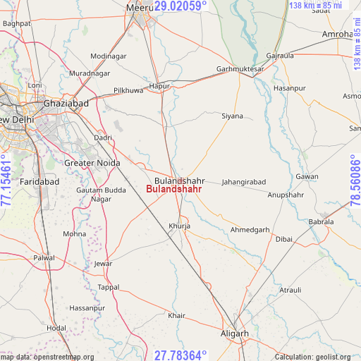
Bulandshahr GPS coordinates[2]
28° 24' 14.112" North, 77° 51' 27.828" East
| Map corner | latitude | longitude |
|---|---|---|
| Upper-left | 29.02059°, | 77.15461° |
| Center: | 28.40392°, | 77.85773° |
| Lower-right: | 27.78364°, | 78.56086° |
| Map W x H: | 137.5×137.5 km | = 85.4×85.4mi |
| max Lat: | 34.9274° ⇑13.7% North |
| Bulandshahr: | 28.40392° |
| min Lat: | ⇓86.3% South 8.09008° |
| min Long | Bulandshahr | max Long |
| 68.82655° | 77.85773° | 96.81° |
| W 47%⇐ | ⇒53% E |
Elevation
Elevation of Bulandshahr is 210 m = 689 ft, and this is 85.6 m = 281 ft below average elevation for this country.
| Max E: |
3681 m = 12077 ft | 48.6% |
| Avg. | 295.6 m = 970 ft | |
| Bulandshahr | 210 m = 689 ft | |
Min E: |
1 m = 3 ft | 51.4% |
See also: Bulandshahr elevation on elevation.city.
Geographical zone
Bulandshahr is located in North temperate zone (between Tropic of Cancer and the Arctic Circle). Distance of this Northern Tropic circle is 552.3 km =343.2 mi to South.| Distance of | km | miles | from Bulandshahr |
|---|---|---|---|
| North Pole | 6848.8 | 4255.6 | to North |
| Arctic Circle | 4243 | 2636.5 | to North |
| Tropic Cancer | 552.3 | 343.2 | to South |
| Equator | 3158.2 | 1962.4 | to South |


Nearby cities:
15 places around Bulandshahr: (largest is in red/bold)
• Babugarh
35.6 km =22.1 mi,  358°
358°
• Bīlāspur
22.9 km =14.2 mi,  266°
266°
• Dankaur
30.2 km =18.8 mi,  258°
258°
• Dādri
34 km =21.1 mi,  299°
299°
• Greater Noida
33.1 km =20.6 mi,  288°
288°
• Gulāothi
21.6 km =13.4 mi,  342°
342°
• Jahāngīrpur
29.1 km =18.1 mi,  210°
210°
• Jahāngīrābād
24.3 km =15.1 mi,  89°
89°
• Khurja
16.7 km =10.4 mi,  180°
180°
• Khānpur
25 km =15.5 mi,  54°
54°
• Pahāsu
32.7 km =20.3 mi,  141°
141°
• Rabūpura
30.2 km =18.8 mi,  235°
235°
• Saidpur
23.6 km =14.7 mi,  12°
12°
• Shikārpūr
20.5 km =12.7 mi,  131°
131°
• Sikandarābād
16.3 km =10.1 mi, 289°
Sources, notices
• [Note1] Compared only with cities in India existing in our database
• [Src1] Map data: © OpenStreetMap contributors (CC-BY-SA)
• [Src2] Other city data from geonames.org with taken over terms of usage.
• [Src3] Geographical zone / Annual Mean Temperature by Robert A. Rohde @ Wikipedia
