Sikandarābād geodata
Sikandarābād (Uttar Pradesh) is a populated place; located in India in Asia/Kolkata (GMT+5.5) time zone. With population of 73,379 people, there are 600 cities with bigger population in this country. Compared to other cities in India, 86.6% of cities are located further ↓South; 55% of cities are located further →East and 51.3% of cities have lower elevation than Sikandarābād. Note1


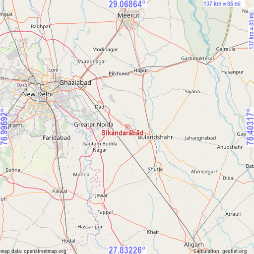
Sikandarābād GPS coordinates[2]
28° 27' 8.136" North, 77° 42' 0.144" East
| Map corner | latitude | longitude |
|---|---|---|
| Upper-left | 29.06864°, | 76.99692° |
| Center: | 28.45226°, | 77.70004° |
| Lower-right: | 27.83226°, | 78.40317° |
| Map W x H: | 137.5×137.5 km | = 85.4×85.4mi |
| max Lat: | 34.9274° ⇑13.4% North |
| Sikandarābād: | 28.45226° |
| min Lat: | ⇓86.6% South 8.09008° |
| min Long | Sikandarābād | max Long |
| 68.82655° | 77.70004° | 96.81° |
| W 45%⇐ | ⇒55% E |
Elevation
Elevation of Sikandarābād is 209 m = 686 ft, and this is 86.6 m = 284 ft below average elevation for this country.
| Max E: |
3681 m = 12077 ft | 48.7% |
| Avg. | 295.6 m = 970 ft | |
| Sikandarābād | 209 m = 686 ft | |
Min E: |
1 m = 3 ft | 51.3% |
See also: Sikandarābād elevation on elevation.city.
Geographical zone
Sikandarābād is located in North temperate zone (between Tropic of Cancer and the Arctic Circle). Distance of this Northern Tropic circle is 557.7 km =346.5 mi to South.| Distance of | km | miles | from Sikandarābād |
|---|---|---|---|
| North Pole | 6843.5 | 4252.4 | to North |
| Arctic Circle | 4237.6 | 2633.1 | to North |
| Tropic Cancer | 557.7 | 346.5 | to South |
| Equator | 3163.6 | 1965.8 | to South |


Nearby cities:
15 places around Sikandarābād: (largest is in red/bold)
• Babugarh
33.4 km =20.8 mi,  25°
25°
• Bulandshahr
16.3 km =10.1 mi,  109°
109°
• Bīlāspur
10 km =6.2 mi,  227°
227°
• Dankaur
18.1 km =11.2 mi, 231°
• Dādri
18.1 km =11.2 mi,  308°
308°
• Dāsna
30.4 km =18.9 mi,  325°
325°
• Ghāziābād
34.8 km =21.6 mi, 312°
• Greater Noida
16.8 km =10.4 mi,  286°
286°
• Gulāothi
17.8 km =11.1 mi, 30°
• Hāpur
31.9 km =19.8 mi,  14°
14°
• Jahāngīrpur
30.4 km =18.9 mi,  179°
179°
• Khurja
26.8 km =16.7 mi,  145°
145°
• Pilkhua
29.3 km =18.2 mi,  351°
351°
• Rabūpura
24.3 km =15.1 mi,  203°
203°
• Saidpur
27 km =16.8 mi,  49°
49°
Sources, notices
• [Note1] Compared only with cities in India existing in our database
• [Src1] Map data: © OpenStreetMap contributors (CC-BY-SA)
• [Src2] Other city data from geonames.org with taken over terms of usage.
• [Src3] Geographical zone / Annual Mean Temperature by Robert A. Rohde @ Wikipedia
