Basmat geodata
Basmat (Maharashtra) is a populated place; located in India in Asia/Kolkata (GMT+5.5) time zone. With population of 63,972 people, there are 689 cities with bigger population in this country. Compared to other cities in India, 67.4% of cities are located further ↑North; 61.4% of cities are located further →East and 75.9% of cities have lower elevation than Basmat. Note1


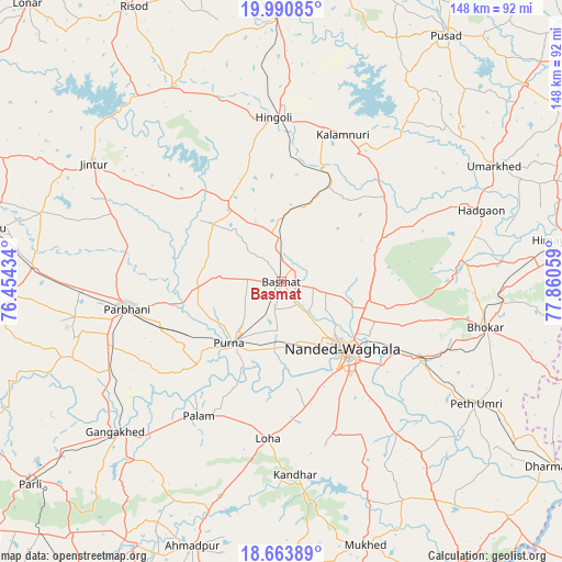
Basmat GPS coordinates[2]
19° 19' 43.392" North, 77° 9' 26.856" East
| Map corner | latitude | longitude |
|---|---|---|
| Upper-left | 19.99085°, | 76.45434° |
| Center: | 19.32872°, | 77.15746° |
| Lower-right: | 18.66389°, | 77.86059° |
| Map W x H: | 147.5×147.5 km | = 91.7×91.7mi |
| max Lat: | 34.9274° ⇑67.4% North |
| Basmat: | 19.32872° |
| min Lat: | ⇓32.6% South 8.09008° |
| min Long | Basmat | max Long |
| 68.82655° | 77.15746° | 96.81° |
| W 38.6%⇐ | ⇒61.4% E |
Elevation
Elevation of Basmat is 397 m = 1302 ft, and this is 101.4 m = 333 ft above average elevation for this country.
| Max E: |
3681 m = 12077 ft | 24.1% |
| Basmat | 397 m 1302 ft | |
| Avg. | 295.6 m = 970 ft | |
Min E: |
1 m = 3 ft | 75.9% |
See also: Basmat elevation on elevation.city.
Geographical zone
Basmat is located in North Torrid zone (between Equator and Tropic of Cancer). Distance of this Northern Tropic circle is 456.8 km =283.8 mi to North.| Distance of | km | miles | from Basmat |
|---|---|---|---|
| North Pole | 7857.9 | 4882.7 | to North |
| Arctic Circle | 5252 | 3263.4 | to North |
| Tropic Cancer | 456.8 | 283.8 | to North |
| Equator | 2149.2 | 1335.5 | to South |


Nearby cities:
15 places around Basmat: (largest is in red/bold)
• Ahmadpur
73 km =45.4 mi,  198°
198°
• Gangākher
58.6 km =36.4 mi,  227°
227°
• Hadgāon
55.7 km =34.6 mi,  70°
70°
• Hingoli
42.9 km =26.7 mi,  357°
357°
• Jintūr
58.5 km =36.4 mi,  302°
302°
• Kalamnūri
41.6 km =25.8 mi,  22°
22°
• Mudkhed
41 km =25.5 mi,  117°
117°
• Mukher
72.7 km =45.2 mi,  162°
162°
• Mānwat
69.3 km =43.1 mi,  267°
267°
• Nanded
25 km =15.5 mi,  138°
138°
• Parbhani
41.1 km =25.5 mi,  260°
260°
• Pāthri
76.3 km =47.4 mi, 264°
• Pūrna
21.4 km =13.3 mi,  220°
220°
• Selu
76.5 km =47.5 mi,  280°
280°
• Umarkhed
63.4 km =39.4 mi,  61°
61°
Sources, notices
• [Note1] Compared only with cities in India existing in our database
• [Src1] Map data: © OpenStreetMap contributors (CC-BY-SA)
• [Src2] Other city data from geonames.org with taken over terms of usage.
• [Src3] Geographical zone / Annual Mean Temperature by Robert A. Rohde @ Wikipedia
