Banbasa geodata
Banbasa (Uttar Pradesh) is a populated place; located in India in Asia/Kolkata (GMT+5.5) time zone. With population of 7,138 people, there are 3202 cities with bigger population in this country. Compared to other cities in India, 89.1% of cities are located further ↓South; 68.3% of cities are located further ←West and 55.8% of cities have lower elevation than Banbasa. Note1


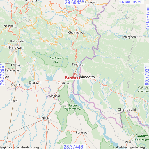
Banbasa GPS coordinates[2]
28° 59' 28.752" North, 80° 4' 33.888" East
| Map corner | latitude | longitude |
|---|---|---|
| Upper-left | 29.6045°, | 79.37296° |
| Center: | 28.99132°, | 80.07608° |
| Lower-right: | 28.37448°, | 80.77921° |
| Map W x H: | 136.8×136.8 km | = 85×85mi |
| max Lat: | 34.9274° ⇑10.9% North |
| Banbasa: | 28.99132° |
| min Lat: | ⇓89.1% South 8.09008° |
| min Long | Banbasa | max Long |
| 68.82655° | 80.07608° | 96.81° |
| W 68.3%⇐ | ⇒31.7% E |
Elevation
Elevation of Banbasa is 229 m = 751 ft, and this is 66.6 m = 219 ft below average elevation for this country.
| Max E: |
3681 m = 12077 ft | 44.2% |
| Avg. | 295.6 m = 970 ft | |
| Banbasa | 229 m = 751 ft | |
Min E: |
1 m = 3 ft | 55.8% |
See also: India elevation on elevation.city.
Geographical zone
Banbasa is located in North temperate zone (between Tropic of Cancer and the Arctic Circle). Distance of this Northern Tropic circle is 617.6 km =383.8 mi to South.| Distance of | km | miles | from Banbasa |
|---|---|---|---|
| North Pole | 6783.5 | 4215.1 | to North |
| Arctic Circle | 4177.6 | 2595.8 | to North |
| Tropic Cancer | 617.6 | 383.8 | to South |
| Equator | 3223.5 | 2003 | to South |


Nearby cities:
15 places around Banbasa: (largest is in red/bold)
• Baheri
61.3 km =38.1 mi,  246°
246°
• Barkhera Kalān
65.5 km =40.7 mi,  203°
203°
• Bhīm Tāl
63.4 km =39.4 mi,  308°
308°
• Champawat
38.2 km =23.7 mi,  0°
0°
• Haldwani
59.1 km =36.7 mi,  295°
295°
• Jahānābād
53.2 km =33.1 mi,  220°
220°
• Khatīma
12.9 km =8 mi,  232°
232°
• Kichha
54.8 km =34.1 mi,  260°
260°
• Kālīnagar
41.3 km =25.7 mi,  179°
179°
• Lohaghāt
45.9 km =28.5 mi, 1°
• Pīlibhīt
48 km =29.8 mi,  213°
213°
• Pūranpur
53.7 km =33.4 mi,  172°
172°
• Richha
63.2 km =39.3 mi,  238°
238°
• Sitārganj
36.8 km =22.9 mi, 259°
• Tanakpur
9.8 km =6.1 mi,  20°
20°
Sources, notices
• [Note1] Compared only with cities in India existing in our database
• [Src1] Map data: © OpenStreetMap contributors (CC-BY-SA)
• [Src2] Other city data from geonames.org with taken over terms of usage.
• [Src3] Geographical zone / Annual Mean Temperature by Robert A. Rohde @ Wikipedia
