Dhārchula geodata
Dhārchula (Uttarakhand) is a populated place; located in India in Asia/Kolkata (GMT+5.5) time zone. With population of 7,331 people, there are 3186 cities with bigger population in this country. Compared to other cities in India, 92.5% of cities are located further ↓South; 71% of cities are located further ←West and 98.6% of cities have lower elevation than Dhārchula. Note1


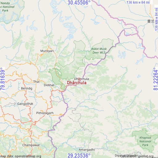
Dhārchula GPS coordinates[2]
29° 50' 49.452" North, 80° 31' 10.236" East
| Map corner | latitude | longitude |
|---|---|---|
| Upper-left | 30.45506°, | 79.81639° |
| Center: | 29.84707°, | 80.51951° |
| Lower-right: | 29.23536°, | 81.22264° |
| Map W x H: | 135.6×135.6 km | = 84.3×84.3mi |
| max Lat: | 34.9274° ⇑7.5% North |
| Dhārchula: | 29.84707° |
| min Lat: | ⇓92.5% South 8.09008° |
| min Long | Dhārchula | max Long |
| 68.82655° | 80.51951° | 96.81° |
| W 71%⇐ | ⇒29% E |
Elevation
Elevation of Dhārchula is 1665 m = 5463 ft, and this is 1369.4 m = 4493 ft above average elevation for this country.
| Max E: |
3681 m = 12077 ft | 1.4% |
| Dhārchula | 1665 m 5463 ft | |
| Avg. | 295.6 m = 970 ft | |
Min E: |
1 m = 3 ft | 98.6% |
See also: India elevation on elevation.city.
Geographical zone
Dhārchula is located in North temperate zone (between Tropic of Cancer and the Arctic Circle). Distance of this Northern Tropic circle is 712.8 km =442.9 mi to South.| Distance of | km | miles | from Dhārchula |
|---|---|---|---|
| North Pole | 6688.4 | 4156 | to North |
| Arctic Circle | 4082.5 | 2536.7 | to North |
| Tropic Cancer | 712.8 | 442.9 | to South |
| Equator | 3318.7 | 2062.1 | to South |


Nearby cities:
15 places around Dhārchula: (largest is in red/bold)
• Almora
87.6 km =54.4 mi,  251°
251°
• Banbasa
104.4 km =64.9 mi,  204°
204°
• Bhowali
110.5 km =68.7 mi,  242°
242°
• Bhīm Tāl
108 km =67.1 mi, 238°
• Bāgeshwar
72.1 km =44.8 mi,  269°
269°
• Champawat
71.2 km =44.2 mi,  216°
216°
• Dwārāhāt
105.6 km =65.6 mi, 265°
• Haldwani
118.4 km =73.6 mi,  234°
234°
• Joshīmath
120.9 km =75.1 mi,  310°
310°
• Khatīma
115.9 km =72 mi,  207°
207°
• Lohaghāt
64.5 km =40.1 mi, 220°
• Naini Tāl
115.1 km =71.5 mi, 244°
• Pithorāgarh
41.9 km =26 mi, 225°
• Rānikhet
107.4 km =66.7 mi,  257°
257°
• Tanakpur
94.6 km =58.8 mi, 204°
Sources, notices
• [Note1] Compared only with cities in India existing in our database
• [Src1] Map data: © OpenStreetMap contributors (CC-BY-SA)
• [Src2] Other city data from geonames.org with taken over terms of usage.
• [Src3] Geographical zone / Annual Mean Temperature by Robert A. Rohde @ Wikipedia
