Pūranpur geodata
Pūranpur (Uttar Pradesh) is a populated place; located in India in Asia/Kolkata (GMT+5.5) time zone. With population of 39,988 people, there are 1105 cities with bigger population in this country. Compared to other cities in India, 86.8% of cities are located further ↓South; 68.9% of cities are located further ←West and 52.7% of cities have higher elevation than Pūranpur. Note1


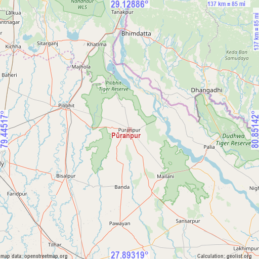
Pūranpur GPS coordinates[2]
28° 30' 46.188" North, 80° 8' 53.844" East
| Map corner | latitude | longitude |
|---|---|---|
| Upper-left | 29.12886°, | 79.44517° |
| Center: | 28.51283°, | 80.14829° |
| Lower-right: | 27.89319°, | 80.85142° |
| Map W x H: | 137.4×137.4 km | = 85.4×85.4mi |
| max Lat: | 34.9274° ⇑13.2% North |
| Pūranpur: | 28.51283° |
| min Lat: | ⇓86.8% South 8.09008° |
| min Long | Pūranpur | max Long |
| 68.82655° | 80.14829° | 96.81° |
| W 68.9%⇐ | ⇒31.1% E |
Elevation
Elevation of Pūranpur is 186 m = 610 ft, and this is 109.6 m = 360 ft below average elevation for this country.
| Max E: |
3681 m = 12077 ft | 52.7% |
| Avg. | 295.6 m = 970 ft | |
| Pūranpur | 186 m = 610 ft | |
Min E: |
1 m = 3 ft | 47.3% |
See also: India elevation on elevation.city.
Geographical zone
Pūranpur is located in North temperate zone (between Tropic of Cancer and the Arctic Circle). Distance of this Northern Tropic circle is 564.4 km =350.7 mi to South.| Distance of | km | miles | from Pūranpur |
|---|---|---|---|
| North Pole | 6836.7 | 4248.1 | to North |
| Arctic Circle | 4230.8 | 2628.9 | to North |
| Tropic Cancer | 564.4 | 350.7 | to South |
| Equator | 3170.3 | 1969.9 | to South |


Nearby cities:
15 places around Pūranpur: (largest is in red/bold)
• Banbasa
53.7 km =33.4 mi,  352°
352°
• Barkhera Kalān
34.1 km =21.2 mi,  258°
258°
• Bilsanda
35.6 km =22.1 mi,  212°
212°
• Bīsalpur
41.6 km =25.8 mi,  233°
233°
• Gola Gokarannāth
57.7 km =35.9 mi,  146°
146°
• Jahānābād
44 km =27.3 mi,  287°
287°
• Khatīma
48.6 km =30.2 mi,  339°
339°
• Khūtār
36.5 km =22.7 mi,  160°
160°
• Kālīnagar
13.6 km =8.5 mi,  331°
331°
• Mailāni
31.2 km =19.4 mi,  142°
142°
• Mohanpur
30.4 km =18.9 mi, 161°
• Nawābganj
50.3 km =31.3 mi,  273°
273°
• Paliā Kalān
43.3 km =26.9 mi,  101°
101°
• Pawāyan
49.9 km =31 mi,  185°
185°
• Pīlibhīt
36.1 km =22.4 mi, 291°
Sources, notices
• [Note1] Compared only with cities in India existing in our database
• [Src1] Map data: © OpenStreetMap contributors (CC-BY-SA)
• [Src2] Other city data from geonames.org with taken over terms of usage.
• [Src3] Geographical zone / Annual Mean Temperature by Robert A. Rohde @ Wikipedia
