Pathānkot geodata
Pathānkot (Punjab) is a populated place; located in India in Asia/Kolkata (GMT+5.5) time zone. With population of 174,306 people, there are 245 cities with bigger population in this country. Compared to other cities in India, 98.3% of cities are located further ↓South; 77% of cities are located further →East and 71.1% of cities have lower elevation than Pathānkot. Note1


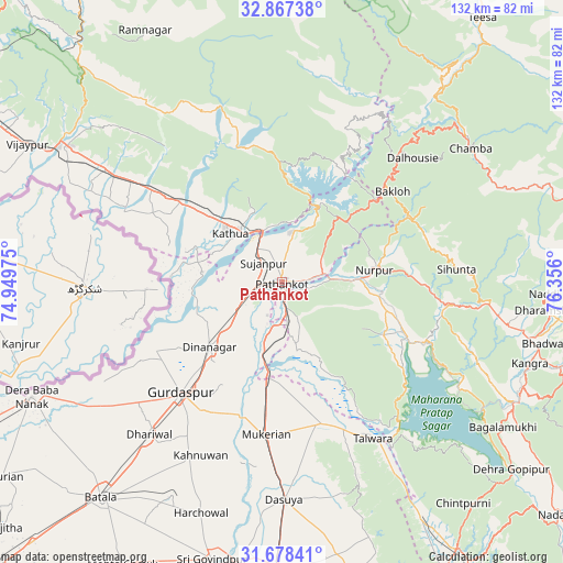
Pathānkot GPS coordinates[2]
32° 16' 29.424" North, 75° 39' 10.332" East
| Map corner | latitude | longitude |
|---|---|---|
| Upper-left | 32.86738°, | 74.94975° |
| Center: | 32.27484°, | 75.65287° |
| Lower-right: | 31.67841°, | 76.356° |
| Map W x H: | 132.2×132.2 km | = 82.1×82.1mi |
| max Lat: | 34.9274° ⇑1.7% North |
| Pathānkot: | 32.27484° |
| min Lat: | ⇓98.3% South 8.09008° |
| min Long | Pathānkot | max Long |
| 68.82655° | 75.65287° | 96.81° |
| W 23%⇐ | ⇒77% E |
Elevation
Elevation of Pathānkot is 337 m = 1106 ft, and this is 41.4 m = 136 ft above average elevation for this country.
| Max E: |
3681 m = 12077 ft | 28.9% |
| Pathānkot | 337 m 1106 ft | |
| Avg. | 295.6 m = 970 ft | |
Min E: |
1 m = 3 ft | 71.1% |
See also: Pathānkot elevation on elevation.city.
Geographical zone
Pathānkot is located in North temperate zone (between Tropic of Cancer and the Arctic Circle). Distance of this Northern Tropic circle is 982.7 km =610.6 mi to South.| Distance of | km | miles | from Pathānkot |
|---|---|---|---|
| North Pole | 6418.4 | 3988.2 | to North |
| Arctic Circle | 3812.5 | 2369 | to North |
| Tropic Cancer | 982.7 | 610.6 | to South |
| Equator | 3588.6 | 2229.9 | to South |


Nearby cities:
15 places around Pathānkot: (largest is in red/bold)
• Bakloh
33.8 km =21 mi,  47°
47°
• Chowari
38 km =23.6 mi,  62°
62°
• Chuāri Khās
38.1 km =23.7 mi, 62°
• Dalhousie
41.4 km =25.7 mi,  41°
41°
• Dasūya
50.9 km =31.6 mi,  179°
179°
• Dhāriwāl
47.1 km =29.3 mi,  221°
221°
• Dīnānagar
22.9 km =14.2 mi,  227°
227°
• Hirānagar
41 km =25.5 mi,  299°
299°
• Hājipur
34.5 km =21.4 mi,  163°
163°
• Kathua
15.9 km =9.9 mi,  311°
311°
• Kotla
35.9 km =22.3 mi,  94°
94°
• Mukeriān
35.8 km =22.2 mi,  185°
185°
• Nagrota
47.9 km =29.8 mi,  120°
120°
• Parol
22 km =13.7 mi,  291°
291°
• Talwāra
43.5 km =27 mi,  149°
149°
Sources, notices
• [Note1] Compared only with cities in India existing in our database
• [Src1] Map data: © OpenStreetMap contributors (CC-BY-SA)
• [Src2] Other city data from geonames.org with taken over terms of usage.
• [Src3] Geographical zone / Annual Mean Temperature by Robert A. Rohde @ Wikipedia
