Kathua geodata
Kathua (Jammu and Kashmir) is a populated place; located in India in Asia/Kolkata (GMT+5.5) time zone. With population of 48,551 people, there are 909 cities with bigger population in this country. Compared to other cities in India, 98.3% of cities are located further ↓South; 78.3% of cities are located further →East and 69.6% of cities have lower elevation than Kathua. Note1


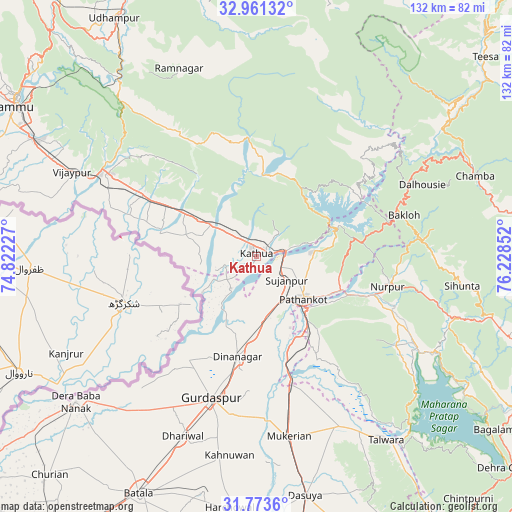
Kathua GPS coordinates[2]
32° 22' 9.876" North, 75° 31' 31.404" East
| Map corner | latitude | longitude |
|---|---|---|
| Upper-left | 32.96132°, | 74.82227° |
| Center: | 32.36941°, | 75.52539° |
| Lower-right: | 31.7736°, | 76.22852° |
| Map W x H: | 132.1×132.1 km | = 82.1×82.1mi |
| max Lat: | 34.9274° ⇑1.7% North |
| Kathua: | 32.36941° |
| min Lat: | ⇓98.3% South 8.09008° |
| min Long | Kathua | max Long |
| 68.82655° | 75.52539° | 96.81° |
| W 21.7%⇐ | ⇒78.3% E |
Elevation
Elevation of Kathua is 323 m = 1060 ft, and this is 27.4 m = 90 ft above average elevation for this country.
| Max E: |
3681 m = 12077 ft | 30.4% |
| Kathua | 323 m 1060 ft | |
| Avg. | 295.6 m = 970 ft | |
Min E: |
1 m = 3 ft | 69.6% |
See also: Kathua elevation on elevation.city.
Geographical zone
Kathua is located in North temperate zone (between Tropic of Cancer and the Arctic Circle). Distance of this Northern Tropic circle is 993.2 km =617.1 mi to South.| Distance of | km | miles | from Kathua |
|---|---|---|---|
| North Pole | 6407.9 | 3981.7 | to North |
| Arctic Circle | 3802 | 2362.5 | to North |
| Tropic Cancer | 993.2 | 617.1 | to South |
| Equator | 3599.1 | 2236.4 | to South |


Nearby cities:
15 places around Kathua: (largest is in red/bold)
• Bakloh
38.9 km =24.2 mi,  71°
71°
• Chowari
46.2 km =28.7 mi,  81°
81°
• Chuāri Khās
46.4 km =28.8 mi, 81°
• Dalhousie
44.4 km =27.6 mi,  62°
62°
• Dhāriwāl
49.7 km =30.9 mi,  202°
202°
• Dīnānagar
26.3 km =16.3 mi,  190°
190°
• Hirānagar
25.6 km =15.9 mi,  291°
291°
• Hājipur
48.7 km =30.3 mi,  153°
153°
• Kalanaur
53.1 km =33 mi,  221°
221°
• Kotla
49.5 km =30.8 mi,  105°
105°
• Mukeriān
47 km =29.2 mi,  169°
169°
• Parol
8.9 km =5.5 mi,  253°
253°
• Pathānkot
15.9 km =9.9 mi,  131°
131°
• Rāmnagar
52.7 km =32.7 mi,  337°
337°
• Sāmba
43.7 km =27.2 mi,  299°
299°
Sources, notices
• [Note1] Compared only with cities in India existing in our database
• [Src1] Map data: © OpenStreetMap contributors (CC-BY-SA)
• [Src2] Other city data from geonames.org with taken over terms of usage.
• [Src3] Geographical zone / Annual Mean Temperature by Robert A. Rohde @ Wikipedia
