Pāthardi geodata
Pāthardi (Maharashtra) is a populated place; located in India in Asia/Kolkata (GMT+5.5) time zone. With population of 24,091 people, there are 1767 cities with bigger population in this country. Compared to other cities in India, 68% of cities are located further ↑North; 81.2% of cities are located further →East and 85% of cities have lower elevation than Pāthardi. Note1


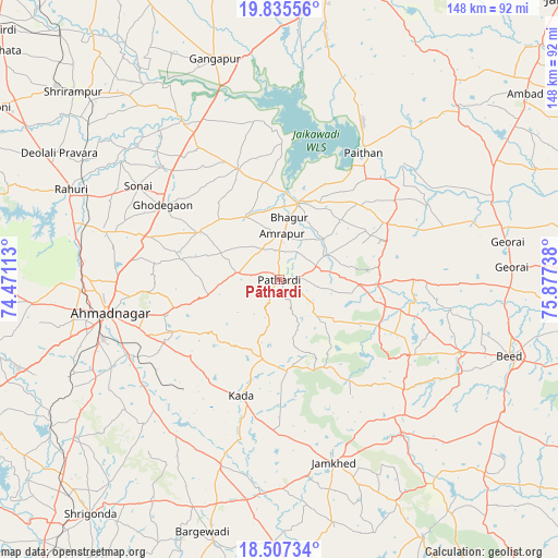
Pāthardi GPS coordinates[2]
19° 10' 22.044" North, 75° 10' 27.3" East
| Map corner | latitude | longitude |
|---|---|---|
| Upper-left | 19.83556°, | 74.47113° |
| Center: | 19.17279°, | 75.17425° |
| Lower-right: | 18.50734°, | 75.87738° |
| Map W x H: | 147.7×147.7 km | = 91.8×91.8mi |
| max Lat: | 34.9274° ⇑68% North |
| Pāthardi: | 19.17279° |
| min Lat: | ⇓32% South 8.09008° |
| min Long | Pāthardi | max Long |
| 68.82655° | 75.17425° | 96.81° |
| W 18.8%⇐ | ⇒81.2% E |
Elevation
Elevation of Pāthardi is 550 m = 1804 ft, and this is 254.4 m = 835 ft above average elevation for this country.
| Max E: |
3681 m = 12077 ft | 15% |
| Pāthardi | 550 m 1804 ft | |
| Avg. | 295.6 m = 970 ft | |
Min E: |
1 m = 3 ft | 85% |
See also: India elevation on elevation.city.
Geographical zone
Pāthardi is located in North Torrid zone (between Equator and Tropic of Cancer). Distance of this Northern Tropic circle is 474.1 km =294.6 mi to North.| Distance of | km | miles | from Pāthardi |
|---|---|---|---|
| North Pole | 7875.2 | 4893.4 | to North |
| Arctic Circle | 5269.4 | 3274.3 | to North |
| Tropic Cancer | 474.1 | 294.6 | to North |
| Equator | 2131.8 | 1324.6 | to South |


Nearby cities:
15 places around Pāthardi: (largest is in red/bold)
• Ahmadnagar
46.6 km =29 mi,  259°
259°
• Ambad
81 km =50.3 mi,  52°
52°
• Aurangabad
80.3 km =49.9 mi,  12°
12°
• Beed
64.5 km =40.1 mi,  108°
108°
• Daulatābād
85 km =52.8 mi,  3°
3°
• Gangāpur
60.8 km =37.8 mi,  343°
343°
• Gevrai
61.3 km =38.1 mi,  80°
80°
• Karmāla
85.1 km =52.9 mi,  178°
178°
• Khuldābād
92.7 km =57.6 mi, 1°
• Paithan
40.3 km =25 mi,  33°
33°
• Pīpri
78.7 km =48.9 mi, 28°
• Rāhuri
60.1 km =37.3 mi,  293°
293°
• Shrīgonda
79.6 km =49.5 mi,  218°
218°
• Sirūr
92.4 km =57.4 mi,  245°
245°
• Ārangaon
50.9 km =31.6 mi, 251°
Sources, notices
• [Note1] Compared only with cities in India existing in our database
• [Src1] Map data: © OpenStreetMap contributors (CC-BY-SA)
• [Src2] Other city data from geonames.org with taken over terms of usage.
• [Src3] Geographical zone / Annual Mean Temperature by Robert A. Rohde @ Wikipedia
