Rājāpur geodata
Rājāpur (Uttar Pradesh) is a populated place; located in India in Asia/Kolkata (GMT+5.5) time zone. With population of 13,962 people, there are 2567 cities with bigger population in this country. Compared to other cities in India, 65.9% of cities are located further ↓South; 73.5% of cities are located further ←West and 66.3% of cities have higher elevation than Rājāpur. Note1


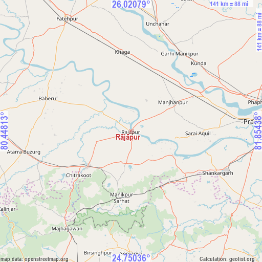
Rājāpur GPS coordinates[2]
25° 23' 14.1" North, 81° 9' 4.5" East
| Map corner | latitude | longitude |
|---|---|---|
| Upper-left | 26.02079°, | 80.44813° |
| Center: | 25.38725°, | 81.15125° |
| Lower-right: | 24.75036°, | 81.85438° |
| Map W x H: | 141.3×141.3 km | = 87.8×87.8mi |
| max Lat: | 34.9274° ⇑34.1% North |
| Rājāpur: | 25.38725° |
| min Lat: | ⇓65.9% South 8.09008° |
| min Long | Rājāpur | max Long |
| 68.82655° | 81.15125° | 96.81° |
| W 73.5%⇐ | ⇒26.5% E |
Elevation
Elevation of Rājāpur is 111 m = 364 ft, and this is 184.6 m = 606 ft below average elevation for this country.
| Max E: |
3681 m = 12077 ft | 66.3% |
| Avg. | 295.6 m = 970 ft | |
| Rājāpur | 111 m = 364 ft | |
Min E: |
1 m = 3 ft | 33.7% |
See also: India elevation on elevation.city.
Geographical zone
Rājāpur is located in North temperate zone (between Tropic of Cancer and the Arctic Circle). Distance of this Northern Tropic circle is 216.9 km =134.8 mi to South.| Distance of | km | miles | from Rājāpur |
|---|---|---|---|
| North Pole | 7184.3 | 4464.1 | to North |
| Arctic Circle | 4578.4 | 2844.9 | to North |
| Tropic Cancer | 216.9 | 134.8 | to South |
| Equator | 2822.8 | 1754 | to South |


Nearby cities:
15 places around Rājāpur: (largest is in red/bold)
• Baberu
48.2 km =30 mi,  291°
291°
• Bharwāri
39.2 km =24.4 mi,  60°
60°
• Bisenda Buzurg
53.5 km =33.2 mi,  271°
271°
• Chail
48.5 km =30.1 mi,  84°
84°
• Karārī
28.6 km =17.8 mi, 75°
• Khāga
43.1 km =26.8 mi,  353°
353°
• Kishanpur
31.2 km =19.4 mi,  335°
335°
• Kotwa
43.1 km =26.8 mi,  156°
156°
• Kunda
51.7 km =32.1 mi,  44°
44°
• Manjhanpur
27.6 km =17.1 mi,  54°
54°
• Mānikpur
36.7 km =22.8 mi,  188°
188°
• Oran
41.1 km =25.5 mi, 267°
• Sarāi Ākil
36.1 km =22.4 mi,  91°
91°
• Shankargarh
52.2 km =32.4 mi,  115°
115°
• Sirāthu
33 km =20.5 mi,  30°
30°
Sources, notices
• [Note1] Compared only with cities in India existing in our database
• [Src1] Map data: © OpenStreetMap contributors (CC-BY-SA)
• [Src2] Other city data from geonames.org with taken over terms of usage.
• [Src3] Geographical zone / Annual Mean Temperature by Robert A. Rohde @ Wikipedia
