Nautanwa geodata
Nautanwa (Uttar Pradesh) is a populated place; located in India in Asia/Kolkata (GMT+5.5) time zone. With population of 32,587 people, there are 1336 cities with bigger population in this country. Compared to other cities in India, 81.3% of cities are located further ↓South; 80.6% of cities are located further ←West and 67.4% of cities have higher elevation than Nautanwa. Note1


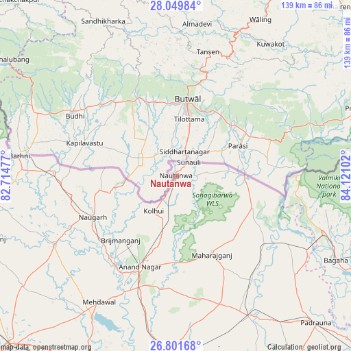
Nautanwa GPS coordinates[2]
27° 25' 39.072" North, 83° 25' 4.404" East
| Map corner | latitude | longitude |
|---|---|---|
| Upper-left | 28.04984°, | 82.71477° |
| Center: | 27.42752°, | 83.41789° |
| Lower-right: | 26.80168°, | 84.12102° |
| Map W x H: | 138.8×138.8 km | = 86.2×86.2mi |
| max Lat: | 34.9274° ⇑18.7% North |
| Nautanwa: | 27.42752° |
| min Lat: | ⇓81.3% South 8.09008° |
| min Long | Nautanwa | max Long |
| 68.82655° | 83.41789° | 96.81° |
| W 80.6%⇐ | ⇒19.4% E |
Elevation
Elevation of Nautanwa is 105 m = 344 ft, and this is 190.6 m = 625 ft below average elevation for this country.
| Max E: |
3681 m = 12077 ft | 67.4% |
| Avg. | 295.6 m = 970 ft | |
| Nautanwa | 105 m = 344 ft | |
Min E: |
1 m = 3 ft | 32.6% |
See also: India elevation on elevation.city.
Geographical zone
Nautanwa is located in North temperate zone (between Tropic of Cancer and the Arctic Circle). Distance of this Northern Tropic circle is 443.7 km =275.7 mi to South.| Distance of | km | miles | from Nautanwa |
|---|---|---|---|
| North Pole | 6957.4 | 4323.1 | to North |
| Arctic Circle | 4351.5 | 2703.9 | to North |
| Tropic Cancer | 443.7 | 275.7 | to South |
| Equator | 3049.7 | 1895 | to South |


Nearby cities:
15 places around Nautanwa: (largest is in red/bold)
• Anandnagar
39.1 km =24.3 mi,  201°
201°
• Bagaha
75.8 km =47.1 mi,  118°
118°
• Bānsi
55.3 km =34.4 mi,  239°
239°
• Captainganj
62.9 km =39.1 mi,  152°
152°
• Gorakhpur
73.7 km =45.8 mi,  183°
183°
• Khada
53.4 km =33.2 mi, 120°
• Khalīlābād
80.5 km =50 mi,  205°
205°
• Maghar
80 km =49.7 mi, 201°
• Mahārāganj
34.5 km =21.4 mi,  155°
155°
• Mehndāwal
58.7 km =36.5 mi, 211°
• Nichlaul
32.9 km =20.4 mi,  112°
112°
• Pachperwa
77 km =47.8 mi,  277°
277°
• Pipraich
67.6 km =42 mi,  170°
170°
• Rāmkola
71.7 km =44.6 mi,  144°
144°
• Siswā Bāzār
45.9 km =28.5 mi,  132°
132°
Sources, notices
• [Note1] Compared only with cities in India existing in our database
• [Src1] Map data: © OpenStreetMap contributors (CC-BY-SA)
• [Src2] Other city data from geonames.org with taken over terms of usage.
• [Src3] Geographical zone / Annual Mean Temperature by Robert A. Rohde @ Wikipedia
